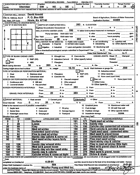
Lithologic Log
(Log data entered by KGS.) |
| |
From: 0 ft. to 2 ft. |
Surface |
| |
From: 2 ft. to 20 ft. |
Loess |
| |
From: 20 ft. to 60 ft. |
Clay |
| |
From: 60 ft. to 75 ft. |
Medium sand with clay |
| |
From: 75 ft. to 76 ft. |
Cemented sand with clay |
| |
From: 76 ft. to 82 ft. |
Fine to medium sand with clay |
| |
From: 82 ft. to 90 ft. |
Sandy clay caliche and some sand |
| |
From: 90 ft. to 110 ft. |
Medium sand with clay layers fairly loose |
| |
From: 110 ft. to 126 ft. |
Sandy clay with sand streaks |
| |
From: 126 ft. to 134 ft. |
Medium sand and gravel loose |
| |
From: 134 ft. to 140 ft. |
Sandy clay with a few sand streaks |
| |
From: 140 ft. to 150 ft. |
Sandy clay and caliche |
| |
From: 150 ft. to 161 ft. |
Caliche with clay and some sand tight |
| |
From: 161 ft. to 171 ft. |
Tight medium sand with clay |
| |
From: 171 ft. to 174 ft. |
Sandy clay |
| |
From: 174 ft. to 190 ft. |
Caliche clay cemented sand with some sand |
| |
From: 190 ft. to 201 ft. |
Hard caliche and cemented sand |
| |
From: 201 ft. to 206 ft. |
Tight medium sand, cemented streaks |
| |
From: 206 ft. to 211 ft. |
Medium sand and gravel loose |
| |
From: 211 ft. to 220 ft. |
Cemented sand with tight medium sand |
| |
From: 220 ft. to 225 ft. |
Fine medium sand with clay |
| |
From: 225 ft. to 230 ft. |
Hard sticky clay and caliche |
| |
From: 230 ft. to 240 ft. |
Fine to medium sand with clay little tight |
| |
From: 240 ft. to 260 ft. |
Medium sand and gravel clean and loose |
| |
From: 260 ft. to 265 ft. |
Sticky clay |
| |
From: 265 ft. to 278 ft. |
Medium sand and gravel, loose |
| |
From: 278 ft. to 283 ft. |
Ochre and shale |