|
|
|
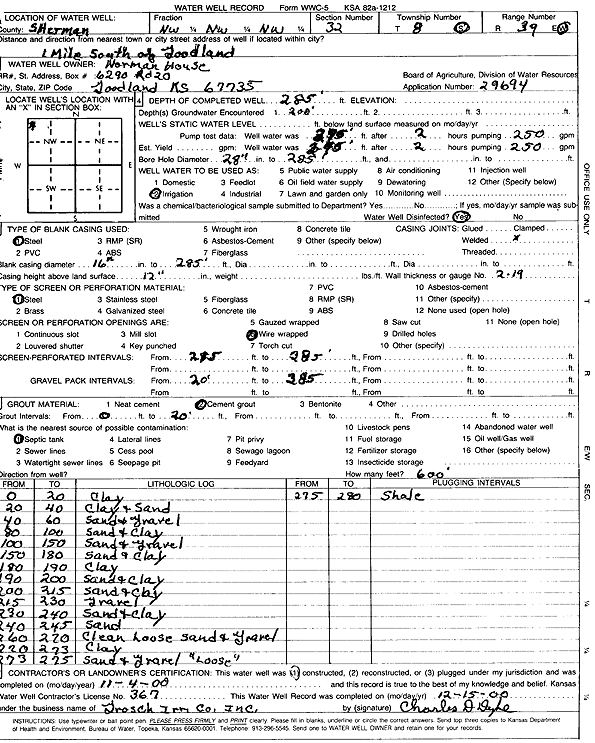
Specific Water Well Detail |
|
|
| Location Info | |||
| Owner: House, Norman | Status: Constructed | ||
| Location: T8S, R39W, Sec. 32, NW NW NW | County: Sherman | ||
| Directions: 1 mi S of Goodland | |||
| Latitude: 39.3213449 | Longitude: -101.7059485 | Datum NAD 27 | |
| Latitude: 39.3213453 | Longitude: -101.7063984 | Datum NAD 83 | |
| Longitude and latitude calculated by Survey from township-range-section-quarter calls. Only good to within the quarter call accuracy. | |||
| View well on interactive map | |||
| General Info | ||
| Well Depth: 285 ft. | Elevation: ft. | |
| Static Water Level: ft. | Est. Yield: gpm. | |
| Comp. Date: 04-Nov-2000 | Well Use: Irrigation | |
| DWR Applic. #: 29694 | Other ID: | |
| Links | |
| No Wizard information available. | |
| View info from WIMAS Water Right Data base... | |
| Driller Info | ||
| Driller: Dick Grosch lrrigaing Co., Inc. | License #: 367 | |
| Scanned Form | View scan |
|
Chemical Sample Submitted?:
Water Well disinfected?: | ||
| Casing Info | ||
| Casing Type:
Casing Joints: |
Diam: in. to ft | |
| Casing height above land surface: in
Casing Weight: lbs/ft Wall thickness or gauge no.: | ||
| Screen and Perforation Info | ||
| Screen Type: | Screen Openings: | |
| Screen-perforated intervals | From: ft to ft | |
| Gravel pack intervals | From: ft to ft | |
| Grout Info | ||
| Grout used: | From: to ft | |
| Source of Possible Contamination | ||
| Source: | ||
| Direction from well: | Distance: ft | |
| Lithologic Log
(Log data entered by KGS.) | ||
| From: 0 ft. to 20 ft. | Clay | |
| From: 20 ft. to 40 ft. | Clay and gravel | |
| From: 40 ft. to 60 ft. | Sand and gravel | |
| From: 80 ft. to 100 ft. | Sand and clay | |
| From: 100 ft. to 150 ft. | Sand and gravel | |
| From: 150 ft. to 180 ft. | Sand and clay | |
| From: 180 ft. to 190 ft. | Clay | |
| From: 190 ft. to 200 ft. | Sand and clay | |
| From: 200 ft. to 215 ft. | Sand and clay | |
| From: 215 ft. to 230 ft. | Gravel | |
| From: 230 ft. to 240 ft. | Sand and clay | |
| From: 240 ft. to 245 ft. | Sand | |
| From: 260 ft. to 270 ft. | Clean loose sand and gravel | |
| From: 270 ft. to 273 ft. | Clay | |
| From: 273 ft. to 275 ft. | Sand and gravel, loose | |
| From: 275 ft. to 280 ft. | Shale | |