|
|
|
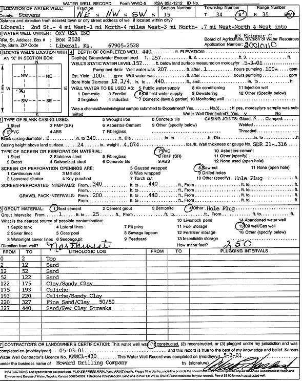
Specific Water Well Detail |
|
|
| Location Info | |||
| Owner: Oxy USA, Inc. | Status: Constructed | ||
| Location: T34S, R35W, Sec. 15, NE NW SW | County: Stevens | ||
| Directions: from Liberal: 2nd St, 8 mi W, 4 mi N, .7 mi NW into site | |||
| Latitude: 37.0893469 | Longitude: -101.1177582 | Datum NAD 27 | |
| Latitude: 37.0893724 | Longitude: -101.1182001 | Datum NAD 83 | |
| Longitude and latitude calculated by Survey from township-range-section-quarter calls. Only good to within the quarter call accuracy. | |||
| View well on interactive map | |||
| General Info | ||
| Well Depth: 440 ft. | Elevation: ft. | |
| Static Water Level: 157 ft. | Est. Yield: 100 gpm. | |
| Comp. Date: 03-May-2001 | Well Use: Oil Field Water Supply | |
| DWR Applic. #: 20010110 | Other ID: Skinner C 3 | |
| Links | |
| No Wizard information available. | |
| View info from WIMAS Water Right Data base... | |
| Driller Info | ||
| Driller: Howard Drilling Company AG, LLC | License #: 430 | |
| Scanned Form | View scan |
|
Chemical Sample Submitted?:
Water Well disinfected?: | ||
| Casing Info | ||
| Casing Type:
Casing Joints: |
Diam: in. to ft | |
| Casing height above land surface: in
Casing Weight: lbs/ft Wall thickness or gauge no.: | ||
| Screen and Perforation Info | ||
| Screen Type: | Screen Openings: | |
| Screen-perforated intervals | From: ft to ft | |
| Gravel pack intervals | From: ft to ft | |
| Grout Info | ||
| Grout used: | From: to ft | |
| Source of Possible Contamination | ||
| Source: | ||
| Direction from well: | Distance: ft | |
| Lithologic Log
(Log data entered by KGS.) | ||
| From: 0 ft. to 2 ft. | top | |
| From: 2 ft. to 12 ft. | sand | |
| From: 12 ft. to 52 ft. | sand | |
| From: 52 ft. to 122 ft. | sand | |
| From: 122 ft. to 175 ft. | clay/sandy clay | |
| From: 175 ft. to 193 ft. | caliche | |
| From: 193 ft. to 220 ft. | caliche/sandy clay | |
| From: 220 ft. to 327 ft. | fine sand/clay 50/50 | |
| From: 327 ft. to 440 ft. | sand/few clay streaks | |