|
|
|
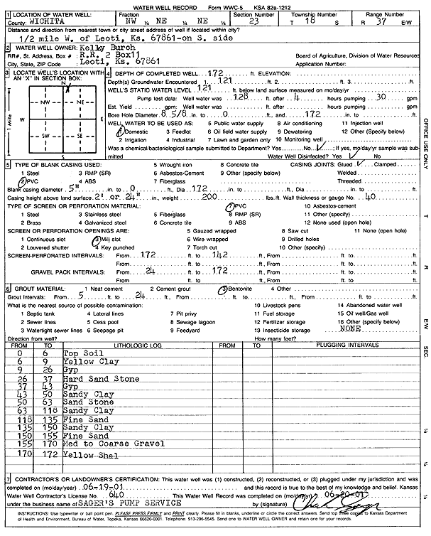
Specific Water Well Detail |
|
|
| Location Info | |||
| Owner: Burch, Kelley | Status: Constructed | ||
| Location: T18S, R37W, Sec. 23, NW NE NE | County: Wichita | ||
| Directions: from Leoti, 0.5 mi W, on S side | |||
| Latitude: 38.4804555 | Longitude: -101.3705474 | Datum NAD 27 | |
| Latitude: 38.4804742 | Longitude: -101.3709858 | Datum NAD 83 | |
| Longitude and latitude calculated by Survey from township-range-section-quarter calls. Only good to within the quarter call accuracy. | |||
| View well on interactive map | |||
| General Info | ||
| Well Depth: 172 ft. | Elevation: ft. | |
| Static Water Level: 121 ft. | Est. Yield: gpm. | |
| Comp. Date: 19-Jun-2001 | Well Use: Domestic | |
| DWR Applic. #: | Other ID: | |
| Driller Info | ||
| Driller: Sager's Pump Service | License #: 640 | |
| Scanned Form | View scan |
|
Chemical Sample Submitted?:
Water Well disinfected?: | ||
| Casing Info | ||
| Casing Type:
Casing Joints: |
Diam: in. to ft | |
| Casing height above land surface: in
Casing Weight: lbs/ft Wall thickness or gauge no.: | ||
| Screen and Perforation Info | ||
| Screen Type: | Screen Openings: | |
| Screen-perforated intervals | From: ft to ft | |
| Gravel pack intervals | From: ft to ft | |
| Grout Info | ||
| Grout used: | From: to ft | |
| Source of Possible Contamination | ||
| Source: | ||
| Direction from well: | Distance: ft | |
| Lithologic Log
(Log data entered by KGS.) | ||
| From: 0 ft. to 6 ft. | Top soil | |
| From: 6 ft. to 9 ft. | Yellow clay | |
| From: 9 ft. to 26 ft. | Gypsum | |
| From: 26 ft. to 37 ft. | Hard sandstone | |
| From: 37 ft. to 43 ft. | Gypsum | |
| From: 43 ft. to 50 ft. | Sandy clay | |
| From: 50 ft. to 63 ft. | Sandstone | |
| From: 63 ft. to 118 ft. | Sandy clay | |
| From: 118 ft. to 135 ft. | Fine sand | |
| From: 135 ft. to 150 ft. | Sandy clay | |
| From: 150 ft. to 155 ft. | Fine sand | |
| From: 155 ft. to 170 ft. | Medium to coarse gravel | |
| From: 170 ft. to 172 ft. | Yellow shale | |