|
|
|
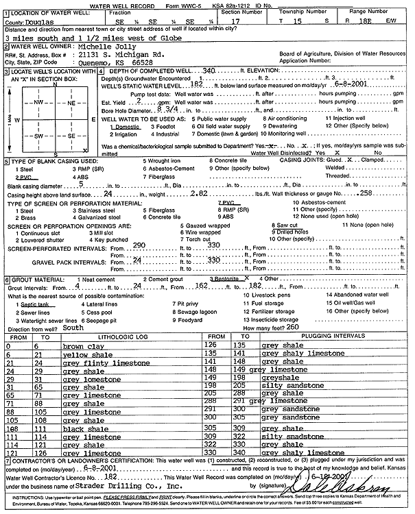
Specific Water Well Detail |
|
|
| Location Info | |||
| Owner: Jolly, Michelle | Status: Constructed | ||
| Location: T15S, R18E, Sec. 17, SE SE SE | County: Douglas | ||
| Directions: from Globe, 3 mi S and 1.5 mi W | |||
| Latitude: 38.7397858 | Longitude: -95.428222 | Datum NAD 27 | |
| Latitude: 38.7397923 | Longitude: -95.4284775 | Datum NAD 83 | |
| Longitude and latitude calculated by Survey from township-range-section-quarter calls. Only good to within the quarter call accuracy. | |||
| View well on interactive map | |||
| General Info | ||
| Well Depth: 340 ft. | Elevation: ft. | |
| Static Water Level: 185 ft. | Est. Yield: 2 gpm. | |
| Comp. Date: 08-Jun-2001 | Well Use: Domestic | |
| DWR Applic. #: | Other ID: | |
| Driller Info | ||
| Driller: Strader Drilling Co., Inc. | License #: 182 | |
| Scanned Form | View scan |
|
Chemical Sample Submitted?:
Water Well disinfected?: | ||
| Casing Info | ||
| Casing Type:
Casing Joints: |
Diam: in. to ft | |
| Casing height above land surface: in
Casing Weight: lbs/ft Wall thickness or gauge no.: | ||
| Screen and Perforation Info | ||
| Screen Type: | Screen Openings: | |
| Screen-perforated intervals | From: ft to ft | |
| Gravel pack intervals | From: ft to ft | |
| Grout Info | ||
| Grout used: | From: to ft | |
| Source of Possible Contamination | ||
| Source: | ||
| Direction from well: | Distance: ft | |
| Lithologic Log
(Log data entered by KGS.) | ||
| From: 0 ft. to 6 ft. | Brown clay | |
| From: 6 ft. to 21 ft. | Yellow shale | |
| From: 21 ft. to 24 ft. | Gray flinty limestone | |
| From: 24 ft. to 29 ft. | Gray shale | |
| From: 29 ft. to 31 ft. | Gray limestone | |
| From: 31 ft. to 65 ft. | Gray shale | |
| From: 65 ft. to 71 ft. | Gray limestone | |
| From: 71 ft. to 88 ft. | Gray shale | |
| From: 88 ft. to 105 ft. | Gray limestone | |
| From: 105 ft. to 108 ft. | Gray shale | |
| From: 108 ft. to 111 ft. | Black shale | |
| From: 111 ft. to 114 ft. | Gray limestone | |
| From: 114 ft. to 121 ft. | Gray shale | |
| From: 121 ft. to 126 ft. | Gray limestone | |
| From: 126 ft. to 135 ft. | Gray shale | |
| From: 135 ft. to 141 ft. | Gray shaley limestone | |
| From: 141 ft. to 148 ft. | Gray shale | |
| From: 148 ft. to 149 ft. | Gray limestone | |
| From: 149 ft. to 198 ft. | Gray shale | |
| From: 198 ft. to 205 ft. | Silty sandstone | |
| From: 205 ft. to 288 ft. | Gray shale | |
| From: 288 ft. to 291 ft. | Gray limestone | |
| From: 291 ft. to 300 ft. | Gray sandstone | |
| From: 300 ft. to 305 ft. | Gray sandstone | |
| From: 305 ft. to 309 ft. | Gray shale | |
| From: 309 ft. to 322 ft. | Silty sandstone | |
| From: 322 ft. to 330 ft. | Gray shale | |
| From: 330 ft. to 340 ft. | Gray shaley limestone | |