|
|
|
Specific Water Well Detail |
|
|
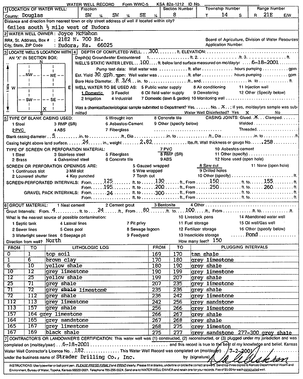
| Location Info | |||
| Owner: McMahon, Joyce | Status: Constructed | ||
| Location: T14S, R21E, Sec. 8, SW SW SE | County: Douglas | ||
| Directions: from Eudora, 6 mi S, .5 mi W | |||
| Latitude: 38.8415789 | Longitude: -95.1010149 | Datum NAD 27 | |
| Latitude: 38.841585 | Longitude: -95.1012622 | Datum NAD 83 | |
| Longitude and latitude calculated by Survey from township-range-section-quarter calls. Only good to within the quarter call accuracy. | |||
| View well on interactive map | |||
| General Info | ||
| Well Depth: 300 ft. | Elevation: ft. | |
| Static Water Level: 100 ft. | Est. Yield: 30 gpm. | |
| Comp. Date: 18-Jun-2001 | Well Use: Domestic | |
| DWR Applic. #: | Other ID: | |
| Driller Info | ||
| Driller: Strader Drilling Co., Inc. | License #: 182 | |
| Scanned Form | View scan |
|
Chemical Sample Submitted?:
Water Well disinfected?: | ||
| Casing Info | ||
| Casing Type:
Casing Joints: |
Diam: in. to ft | |
| Casing height above land surface: in
Casing Weight: lbs/ft Wall thickness or gauge no.: | ||
| Screen and Perforation Info | ||
| Screen Type: | Screen Openings: | |
| Screen-perforated intervals | From: ft to ft | |
| Gravel pack intervals | From: ft to ft | |
| Grout Info | ||
| Grout used: | From: to ft | |
| Source of Possible Contamination | ||
| Source: | ||
| Direction from well: | Distance: ft | |
| Lithologic Log
(Log data entered by KGS.) | ||
| From: 0 ft. to 1 ft. | top soil | |
| From: 1 ft. to 6 ft. | brown clay | |
| From: 6 ft. to 10 ft. | yellow shale | |
| From: 10 ft. to 12 ft. | gray limestone | |
| From: 12 ft. to 25 ft. | yellow shale | |
| From: 25 ft. to 71 ft. | gray shale | |
| From: 71 ft. to 72 ft. | gray limestone | |
| From: 72 ft. to 112 ft. | gray shale | |
| From: 112 ft. to 113 ft. | gray limestone | |
| From: 113 ft. to 157 ft. | gray shale | |
| From: 157 ft. to 164 ft. | gray limestone | |
| From: 164 ft. to 165 ft. | gray sandstone | |
| From: 165 ft. to 167 ft. | gray limestone | |
| From: 167 ft. to 169 ft. | black shale | |
| From: 169 ft. to 170 ft. | tan shale | |
| From: 170 ft. to 180 ft. | gray limestone | |
| From: 180 ft. to 190 ft. | gray shale | |
| From: 190 ft. to 199 ft. | gray limestone | |
| From: 199 ft. to 207 ft. | gray shale | |
| From: 207 ft. to 235 ft. | gray limestone | |
| From: 235 ft. to 236 ft. | gray shale | |
| From: 236 ft. to 242 ft. | gray limestone | |
| From: 242 ft. to 256 ft. | gray sandstone | |
| From: 256 ft. to 266 ft. | gray limestone | |
| From: 266 ft. to 267 ft. | gray shale | |
| From: 267 ft. to 268 ft. | gray shale | |
| From: 268 ft. to 275 ft. | gray limestone | |
| From: 275 ft. to 277 ft. | gray sandstone | |
| From: 277 ft. to 300 ft. | gray shale | |