|
|
|
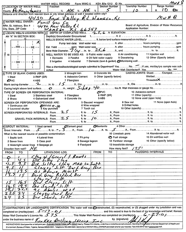
Specific Water Well Detail |
|
|
| Location Info | |||
| Owner: Ferrell Gas Co. | Status: Constructed | ||
| Location: T10S, R10E, Sec. 5, NE NE | County: Pottawatomie | ||
| Directions: 4430 Kaw Valley Rd, Wamego | |||
| Latitude: 39.2154802 | Longitude: -96.3173901 | Datum NAD 27 | |
| Latitude: 39.2154768 | Longitude: -96.3176659 | Datum NAD 83 | |
| Longitude and latitude calculated by Survey from township-range-section-quarter calls. Only good to within the quarter call accuracy. | |||
| View well on interactive map | |||
| General Info | ||
| Well Depth: 25.6 ft. | Elevation: ft. | |
| Static Water Level: ft. | Est. Yield: gpm. | |
| Comp. Date: 17-May-2001 | Well Use: Monitoring well/observation/piezometer | |
| DWR Applic. #: | Other ID: MW 8 | |
| Driller Info | ||
| Driller: Funkee Drilling Service | License #: 575 | |
| Scanned Form | View scan |
|
Chemical Sample Submitted?:
Water Well disinfected?: | ||
| Casing Info | ||
| Casing Type:
Casing Joints: |
Diam: in. to ft | |
| Casing height above land surface: in
Casing Weight: lbs/ft Wall thickness or gauge no.: | ||
| Screen and Perforation Info | ||
| Screen Type: | Screen Openings: | |
| Screen-perforated intervals | From: ft to ft | |
| Gravel pack intervals | From: ft to ft | |
| Grout Info | ||
| Grout used: | From: to ft | |
| Source of Possible Contamination | ||
| Source: | ||
| Direction from well: | Distance: ft | |
| Lithologic Log
(Log data entered by KGS.) | ||
| From: 0 ft. to 1 ft. | clay with gravel and roots | |
| From: 1 ft. to 4.5 ft. | black silty clay | |
| From: 4.5 ft. to 9.5 ft. | black silty clay, medium to soft | |
| From: 9.5 ft. to 11 ft. | clayey silt, dark gray brown | |
| From: 11 ft. to 13.5 ft. | clayey silt, dark gray brown, moist | |
| From: 13.5 ft. to 15 ft. | dark gray reddish brown clayey silt | |
| From: 15 ft. to 16.5 ft. | brown clayey silt | |
| From: 16.5 ft. to 22.5 ft. | brown sandy silt, wet | |
| From: 22.5 ft. to 24 ft. | clayey sand, brown | |
| From: 24 ft. to 25 ft. | brown sandy silt | |