|
|
|
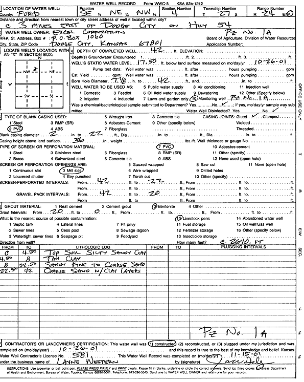
Specific Water Well Detail |
|
|
| Location Info | |||
| Owner: Excel Corporation | Status: Constructed | ||
| Location: T27S, R24W, Sec. 4, SE NE NW | County: Ford | ||
| Directions: from Dodge City: 3 mi E on Hwy 54 | |||
| Latitude: 37.7344224 | Longitude: -99.951808 | Datum NAD 27 | |
| Latitude: 37.734444 | Longitude: -99.952222 | Datum NAD 83 | |
| Longitude and latitude from GPS measurements. | |||
| GPS Latitude: 37.734444 | GPS Longitude: -99.952222 | Datum NAD83 | |
| View well on interactive map | |||
| General Info | ||
| Well Depth: 42 ft. | Elevation: ft. | |
| Static Water Level: 17.5 ft. | Est. Yield: gpm. | |
| Comp. Date: 26-Oct-2001 | Well Use: Monitoring well/observation/piezometer | |
| DWR Applic. #: | Other ID: PZ 1 A | |
| Driller Info | ||
| Driller: Layne Western | License #: 581 | |
| Scanned Form | View scan |
|
Chemical Sample Submitted?:
Water Well disinfected?: | ||
| Casing Info | ||
| Casing Type:
Casing Joints: |
Diam: in. to ft | |
| Casing height above land surface: in
Casing Weight: lbs/ft Wall thickness or gauge no.: | ||
| Screen and Perforation Info | ||
| Screen Type: | Screen Openings: | |
| Screen-perforated intervals | From: ft to ft | |
| Gravel pack intervals | From: ft to ft | |
| Grout Info | ||
| Grout used: | From: to ft | |
| Source of Possible Contamination | ||
| Source: | ||
| Direction from well: | Distance: ft | |
| Lithologic Log
(Log data entered by KGS.) | ||
| From: 0 ft. to 4.5 ft. | topsoil, silty sandy clay | |
| From: 4.5 ft. to 8 ft. | tan clay | |
| From: 8 ft. to 22.5 ft. | sandy fine to coarse sand | |
| From: 22.5 ft. to 42 ft. | coarse sand with clay layers | |