|
|
|
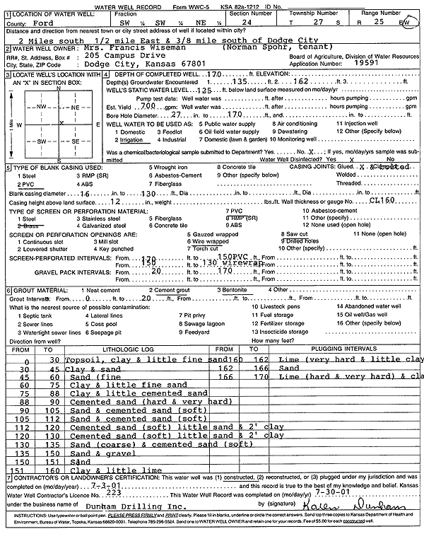
Specific Water Well Detail |
|
|
| Location Info | |||
| Owner: Wiseman, Mrs. Francis | Status: Constructed | ||
| Location: T27S, R25W, Sec. 24, SW SW NE | County: Ford | ||
| Directions: from Dodge City: 2 mi S, .5 mi E, .38 mi S | |||
| Latitude: 37.6861614 | Longitude: -100.0043679 | Datum NAD 27 | |
| Latitude: 37.686182 | Longitude: -100.0047799 | Datum NAD 83 | |
| Longitude and latitude calculated by Survey from township-range-section-quarter calls. Only good to within the quarter call accuracy. | |||
| View well on interactive map | |||
| General Info | ||
| Well Depth: 170 ft. | Elevation: ft. | |
| Static Water Level: 125 ft. | Est. Yield: 700 gpm. | |
| Comp. Date: 03-Jul-2001 | Well Use: Irrigation | |
| DWR Applic. #: 19591 | Other ID: | |
| Links | |
| No Wizard information available. | |
| View info from WIMAS Water Right Data base... | |
| Driller Info | ||
| Driller: Donald R. Dunham Drilling, Inc. | License #: 223 | |
| Scanned Form | View scan |
|
Chemical Sample Submitted?:
Water Well disinfected?: | ||
| Casing Info | ||
| Casing Type:
Casing Joints: |
Diam: in. to ft | |
| Casing height above land surface: in
Casing Weight: lbs/ft Wall thickness or gauge no.: | ||
| Screen and Perforation Info | ||
| Screen Type: | Screen Openings: | |
| Screen-perforated intervals | From: ft to ft | |
| Gravel pack intervals | From: ft to ft | |
| Grout Info | ||
| Grout used: | From: to ft | |
| Source of Possible Contamination | ||
| Source: | ||
| Direction from well: | Distance: ft | |
| Lithologic Log
(Log data entered by KGS.) | ||
| From: 0 ft. to 30 ft. | topsoil, clay and little fine sand | |
| From: 30 ft. to 45 ft. | clay and sand | |
| From: 45 ft. to 60 ft. | sand (fine) | |
| From: 60 ft. to 75 ft. | clay and little fine sand | |
| From: 75 ft. to 88 ft. | clay and little cemented sand | |
| From: 88 ft. to 90 ft. | cemented sand (hard and very hard) | |
| From: 90 ft. to 105 ft. | sand and cemented sand (soft) | |
| From: 105 ft. to 112 ft. | sand and cemented sand (soft) | |
| From: 112 ft. to 120 ft. | cemented sand (soft) little sand and 2 feet clay | |
| From: 120 ft. to 130 ft. | cemented sand (soft) little sand and 2 feet clay | |
| From: 130 ft. to 135 ft. | sand (coarse) and cemented sand (soft) | |
| From: 135 ft. to 150 ft. | sand and gravel | |
| From: 150 ft. to 151 ft. | sand | |
| From: 151 ft. to 160 ft. | clay and little lime | |
| From: 160 ft. to 162 ft. | lime (very hard and little clay) | |
| From: 162 ft. to 166 ft. | sand | |
| From: 166 ft. to 170 ft. | lime (hard and very hard) and clay | |