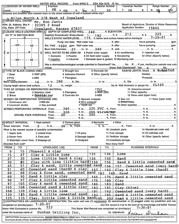
Lithologic Log
(Log data entered by KGS.) |
| |
From: 0 ft. to 15 ft. |
Topsoil and clay |
| |
From: 15 ft. to 27 ft. |
Clay and little lime |
| |
From: 27 ft. to 30 ft. |
Lime (little hard and clay |
| |
From: 30 ft. to 45 ft. |
Clay with Lime (little hard) |
| |
From: 45 ft. to 51 ft. |
Clay and sand, little cemented sand |
| |
From: 51 ft. to 60 ft. |
Cemented sand (hard) and clay |
| |
From: 60 ft. to 68 ft. |
Clay and fine sand, cemented sand |
| |
From: 68 ft. to 90 ft. |
Sand and little clay |
| |
From: 90 ft. to 97 ft. |
Clay and little cemented sand |
| |
From: 97 ft. to 105 ft. |
Clay and sand and cemented sand |
| |
From: 105 ft. to 108 ft. |
Cemented sand and little clay |
| |
From: 108 ft. to 120 ft. |
Clay and little lime |
| |
From: 120 ft. to 125 ft. |
Sand and little cemented sand |
| |
From: 125 ft. to 135 ft. |
Clay, little lime and little sand |
| |
From: 135 ft. to 136 ft. |
Lime |
| |
From: 136 ft. to 150 ft. |
Sand |
| |
From: 150 ft. to 156 ft. |
Sand and little cemented sand |
| |
From: 156 ft. to 157 ft. |
Cemented sand (very hard) |
| |
From: 157 ft. to 162 ft. |
Clay and little lime (hard) |
| |
From: 162 ft. to 165 ft. |
Sand |
| |
From: 165 ft. to 175 ft. |
Sand and little cemented sand |
| |
From: 175 ft. to 180 ft. |
Clay |
| |
From: 180 ft. to 183 ft. |
Sand |
| |
From: 183 ft. to 191 ft. |
Clay (blue) |
| |
From: 191 ft. to 192 ft. |
Cemented sand (very hard) |
| |
From: 192 ft. to 195 ft. |
Sand and little cemented sand |
| |
From: 195 ft. to 202 ft. |
Sand and little cemented sand |