|
|
|
Specific Water Well Detail |
|
|
| Location Info | |||
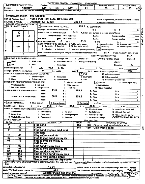
| Owner: Graham, Tod | Status: Constructed | ||
| Location: T23S, R35W, Sec. 21, NW NE NW | County: Kearny | ||
| Directions: | |||
| Latitude: 38.0456194 | Longitude: -101.1698468 | Datum NAD 27 | |
| Latitude: 38.0456409 | Longitude: -101.1702917 | Datum NAD 83 | |
| Longitude and latitude calculated by Survey from township-range-section-quarter calls. Only good to within the quarter call accuracy. | |||
| View well on interactive map | |||
| General Info | ||
| Well Depth: 153.5 ft. | Elevation: ft. | |
| Static Water Level: 104.3 ft. | Est. Yield: gpm. | |
| Comp. Date: 02-Jul-2001 | Well Use: Monitoring well/observation/piezometer | |
| DWR Applic. #: | Other ID: MW 1 | |
| Driller Info | ||
| Driller: Jay C. Woofter Pump & Well, Inc. | License #: 554 | |
| Scanned Form | View scan |
|
Chemical Sample Submitted?:
Water Well disinfected?: | ||
| Casing Info | ||
| Casing Type:
Casing Joints: |
Diam: in. to ft | |
| Casing height above land surface: in
Casing Weight: lbs/ft Wall thickness or gauge no.: | ||
| Screen and Perforation Info | ||
| Screen Type: | Screen Openings: | |
| Screen-perforated intervals | From: ft to ft | |
| Gravel pack intervals | From: ft to ft | |
| Grout Info | ||
| Grout used: | From: to ft | |
| Source of Possible Contamination | ||
| Source: | ||
| Direction from well: | Distance: ft | |
| Lithologic Log
(Log data entered by KGS.) | ||
| From: 0 ft. to .5 ft. | fine sand | |
| From: .5 ft. to 9 ft. | loess | |
| From: 9 ft. to 16 ft. | fine sand with some medium sand and clay lens | |
| From: 16 ft. to 46 ft. | clay with fine sand streak | |
| From: 46 ft. to 62 ft. | fine to medium sand with clay streak | |
| From: 65 ft. to 73 ft. | fine to medium sand with clay and caliche streak | |
| From: 73 ft. to 92 ft. | fine sand with clay lens | |
| From: 92 ft. to 97 ft. | fine to medium sand with clay lens | |
| From: 97 ft. to 109 ft. | fine sand with clay lens | |
| From: 109 ft. to 114 ft. | fine to medium sand with clay lens | |
| From: 114 ft. to 129 ft. | fine to medium sand and gravel | |
| From: 129 ft. to 135 ft. | fine to medium sand with clay streaks | |
| From: 135 ft. to 145 ft. | fine to medium sand with clay lens | |
| From: 145 ft. to 150 ft. | clay with fine sand | |