|
|
|
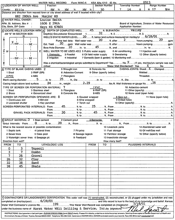
Specific Water Well Detail |
|
|
| Location Info | |||
| Owner: Smith, Louise | Status: Constructed | ||
| Location: T14S, R17W, Sec. 30, SW NW NW | County: Ellis | ||
| Directions: 882 280th Ave, Munjor | |||
| Latitude: 38.8102602 | Longitude: -99.2613931 | Datum NAD 27 | |
| Latitude: 38.8102722 | Longitude: -99.2617724 | Datum NAD 83 | |
| Longitude and latitude calculated by Survey from township-range-section-quarter calls. Only good to within the quarter call accuracy. | |||
| View well on interactive map | |||
| General Info | ||
| Well Depth: 45 ft. | Elevation: ft. | |
| Static Water Level: 20 ft. | Est. Yield: 20 gpm. | |
| Comp. Date: 28-Jun-2001 | Well Use: Domestic | |
| DWR Applic. #: | Other ID: | |
| Driller Info | ||
| Driller: Melvin B. Karst Water Well Drilling & Service, Inc. | License #: 199 | |
| Scanned Form | View scan |
|
Chemical Sample Submitted?:
Water Well disinfected?: | ||
| Casing Info | ||
| Casing Type:
Casing Joints: |
Diam: in. to ft | |
| Casing height above land surface: in
Casing Weight: lbs/ft Wall thickness or gauge no.: | ||
| Screen and Perforation Info | ||
| Screen Type: | Screen Openings: | |
| Screen-perforated intervals | From: ft to ft | |
| Gravel pack intervals | From: ft to ft | |
| Grout Info | ||
| Grout used: | From: to ft | |
| Source of Possible Contamination | ||
| Source: | ||
| Direction from well: | Distance: ft | |
| Lithologic Log
(Log data entered by KGS.) | ||
| From: 0 ft. to 3 ft. | top soil | |
| From: 3 ft. to 7 ft. | gumbo | |
| From: 7 ft. to 26 ft. | gravel | |
| From: 26 ft. to 32 ft. | clay | |
| From: 32 ft. to 38 ft. | sand | |
| From: 38 ft. to 45 ft. | shale | |