|
|
|
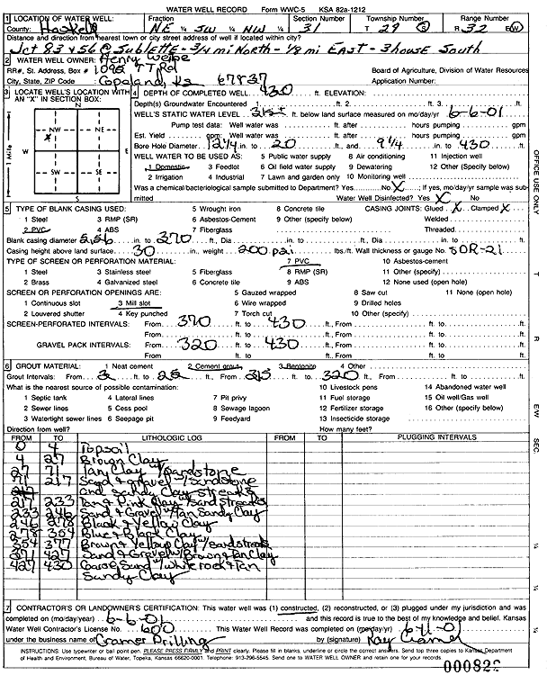
Specific Water Well Detail |
|
|
| Location Info | |||
| Owner: Weibe, Henry | Status: Constructed | ||
| Location: T29S, R32W, Sec. 31, NE SW NW | County: Haskell | ||
| Directions: from Hwy 83 and Hwy 56 at Sublette: .75 mi N, .13 mi E, 3rd house S | |||
| Latitude: 37.484932 | Longitude: -100.8672318 | Datum NAD 27 | |
| Latitude: 37.4849565 | Longitude: -100.867673 | Datum NAD 83 | |
| Longitude and latitude calculated by Survey from township-range-section-quarter calls. Only good to within the quarter call accuracy. | |||
| View well on interactive map | |||
| General Info | ||
| Well Depth: 430 ft. | Elevation: ft. | |
| Static Water Level: 315 ft. | Est. Yield: gpm. | |
| Comp. Date: 06-Jun-2001 | Well Use: Domestic | |
| DWR Applic. #: | Other ID: | |
| Driller Info | ||
| Driller: Ray Cramer Drilling Co. | License #: 600 | |
| Scanned Form | View scan |
|
Chemical Sample Submitted?:
Water Well disinfected?: | ||
| Casing Info | ||
| Casing Type:
Casing Joints: |
Diam: in. to ft | |
| Casing height above land surface: in
Casing Weight: lbs/ft Wall thickness or gauge no.: | ||
| Screen and Perforation Info | ||
| Screen Type: | Screen Openings: | |
| Screen-perforated intervals | From: ft to ft | |
| Gravel pack intervals | From: ft to ft | |
| Grout Info | ||
| Grout used: | From: to ft | |
| Source of Possible Contamination | ||
| Source: | ||
| Direction from well: | Distance: ft | |
| Lithologic Log
(Log data entered by KGS.) | ||
| From: 0 ft. to 4 ft. | topsoil | |
| From: 4 ft. to 27 ft. | brown clay | |
| From: 27 ft. to 71 ft. | tan clay with sandstone | |
| From: 71 ft. to 217 ft. | sand + gravel with sandstone and sandy clay streaks | |
| From: 217 ft. to 233 ft. | tan and pink clay with sand streaks | |
| From: 233 ft. to 246 ft. | sand and gravel with tan sandy clay | |
| From: 246 ft. to 278 ft. | black and yellow clay | |
| From: 278 ft. to 354 ft. | blue and black clay | |
| From: 354 ft. to 377 ft. | brown and yellow clay with sand streaks | |
| From: 377 ft. to 427 ft. | sand and gravel with brown and tan clay | |
| From: 427 ft. to 430 ft. | coarse sand with white rock and tan sandy clay | |