|
|
|
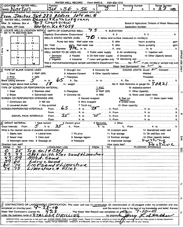
Specific Water Well Detail |
|
|
| Location Info | |||
| Owner: Lofgreen, Denzel and Ruth | Status: Constructed | ||
| Location: T1S, R23W, Sec. 3, SW SE SE | County: Norton | ||
| Directions: from Hwy 36 and Hwy 283, 10.25 mi N | |||
| Latitude: 39.9878433 | Longitude: -99.8917522 | Datum NAD 27 | |
| Latitude: 39.9878498 | Longitude: -99.8921525 | Datum NAD 83 | |
| Longitude and latitude calculated by Survey from township-range-section-quarter calls. Only good to within the quarter call accuracy. | |||
| View well on interactive map | |||
| General Info | ||
| Well Depth: 75 ft. | Elevation: ft. | |
| Static Water Level: 70 ft. | Est. Yield: gpm. | |
| Comp. Date: 28-Sep-2000 | Well Use: Domestic | |
| DWR Applic. #: | Other ID: | |
| Driller Info | ||
| Driller: Leo J. Stalder Drilling | License #: 428 | |
| Scanned Form | View scan |
|
Chemical Sample Submitted?:
Water Well disinfected?: | ||
| Casing Info | ||
| Casing Type:
Casing Joints: |
Diam: in. to ft | |
| Casing height above land surface: in
Casing Weight: lbs/ft Wall thickness or gauge no.: | ||
| Screen and Perforation Info | ||
| Screen Type: | Screen Openings: | |
| Screen-perforated intervals | From: ft to ft | |
| Gravel pack intervals | From: ft to ft | |
| Grout Info | ||
| Grout used: | From: to ft | |
| Source of Possible Contamination | ||
| Source: | ||
| Direction from well: | Distance: ft | |
| Lithologic Log
(Log data entered by KGS.) | ||
| From: 0 ft. to 25 ft. | topsoil and clay | |
| From: 25 ft. to 45 ft. | clay with fine sand and limestone | |
| From: 45 ft. to 59 ft. | medium sand | |
| From: 59 ft. to 60 ft. | large sand | |
| From: 60 ft. to 74 ft. | fine sand and limestone | |
| From: 74 ft. to 75 ft. | limestone and flint | |