|
|
|
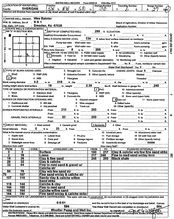
Specific Water Well Detail |
|
|
| Location Info | |||
| Owner: Bainter, Wes | Status: Constructed | ||
| Location: T6S, R27W, Sec. 30, SW NW SE | County: Sheridan | ||
| Directions: | |||
| Latitude: 39.4995929 | Longitude: -100.3751717 | Datum NAD 27 | |
| Latitude: 39.4995965 | Longitude: -100.3755892 | Datum NAD 83 | |
| Longitude and latitude calculated by Survey from township-range-section-quarter calls. Only good to within the quarter call accuracy. | |||
| View well on interactive map | |||
| General Info | ||
| Well Depth: 250 ft. | Elevation: ft. | |
| Static Water Level: 134 ft. | Est. Yield: gpm. | |
| Comp. Date: 06-Jun-2001 | Well Use: Domestic | |
| DWR Applic. #: | Other ID: | |
| Driller Info | ||
| Driller: Woofter Pump & Well, Inc. | License #: 554 | |
| Scanned Form | View scan |
|
Chemical Sample Submitted?:
Water Well disinfected?: | ||
| Casing Info | ||
| Casing Type:
Casing Joints: |
Diam: in. to ft | |
| Casing height above land surface: in
Casing Weight: lbs/ft Wall thickness or gauge no.: | ||
| Screen and Perforation Info | ||
| Screen Type: | Screen Openings: | |
| Screen-perforated intervals | From: ft to ft | |
| Gravel pack intervals | From: ft to ft | |
| Grout Info | ||
| Grout used: | From: to ft | |
| Source of Possible Contamination | ||
| Source: | ||
| Direction from well: | Distance: ft | |
| Lithologic Log
(Log data entered by KGS.) | ||
| From: 0 ft. to 2 ft. | Surface | |
| From: 2 ft. to 18 ft. | Loess | |
| From: 18 ft. to 26 ft. | Clay and fine sand | |
| From: 26 ft. to 32 ft. | Clay and caliche | |
| From: 32 ft. to 54 ft. | Fine to medium sand and gravel with caliche streak | |
| From: 54 ft. to 70 ft. | Clay with a few sand streaks | |
| From: 70 ft. to 107 ft. | Fine sand with clay and caliche streak | |
| From: 107 ft. to 118 ft. | Sandy clay and caliche with fine sand streaks | |
| From: 118 ft. to 144 ft. | Caliche and clay | |
| From: 144 ft. to 155 ft. | Fine to medium sand | |
| From: 155 ft. to 164 ft. | Caliche with fine sand | |
| From: 164 ft. to 180 ft. | Fine sand with clay and caliche streaks | |
| From: 180 ft. to 217 ft. | Clay and caliche with a few fine sand streaks | |
| From: 217 ft. to 248 ft. | Fine to medium sand with clay lens | |
| From: 248 ft. to 260 ft. | Black shale | |