|
|
|
Specific Water Well Detail |
|
|
| Location Info | |||
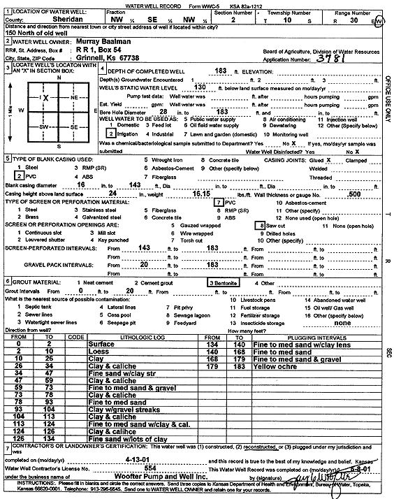
| Owner: Baalman, Murray | Status: Constructed | ||
| Location: T10S, R30W, Sec. 2, NW SE NW | County: Sheridan | ||
| Directions: from old well: 150' N | |||
| Latitude: 39.2154587 | Longitude: -100.6411209 | Datum NAD 27 | |
| Latitude: 39.2154653 | Longitude: -100.6415429 | Datum NAD 83 | |
| Longitude and latitude calculated by Survey from township-range-section-quarter calls. Only good to within the quarter call accuracy. | |||
| View well on interactive map | |||
| General Info | ||
| Well Depth: 183 ft. | Elevation: ft. | |
| Static Water Level: 130 ft. | Est. Yield: gpm. | |
| Comp. Date: 13-Apr-2001 | Well Use: Irrigation | |
| DWR Applic. #: 3781 | Other ID: | |
| Links | |
| No Wizard information available. | |
| View info from WIMAS Water Right Data base... | |
| Driller Info | ||
| Driller: Jay C. Woofter Pump & Well, Inc. | License #: 554 | |
| Scanned Form | View scan |
|
Chemical Sample Submitted?:
Water Well disinfected?: | ||
| Casing Info | ||
| Casing Type:
Casing Joints: |
Diam: in. to ft | |
| Casing height above land surface: in
Casing Weight: lbs/ft Wall thickness or gauge no.: | ||
| Screen and Perforation Info | ||
| Screen Type: | Screen Openings: | |
| Screen-perforated intervals | From: ft to ft | |
| Gravel pack intervals | From: ft to ft | |
| Grout Info | ||
| Grout used: | From: to ft | |
| Source of Possible Contamination | ||
| Source: | ||
| Direction from well: | Distance: ft | |
| Lithologic Log
(Log data entered by KGS.) | ||
| From: 0 ft. to 2 ft. | Surface | |
| From: 2 ft. to 10 ft. | Loess | |
| From: 10 ft. to 26 ft. | Clay | |
| From: 26 ft. to 34 ft. | Clay and caliche | |
| From: 34 ft. to 47 ft. | Fine sand with clay streak | |
| From: 47 ft. to 59 ft. | Clay and caliche | |
| From: 59 ft. to 73 ft. | Fine to medium sand and gravel | |
| From: 73 ft. to 78 ft. | Clay and caliche | |
| From: 78 ft. to 93 ft. | Fine to medium sand | |
| From: 93 ft. to 104 ft. | Clay with gravel streaks | |
| From: 104 ft. to 113 ft. | Clay and caliche | |
| From: 113 ft. to 124 ft. | Fine to medium sand with clay and caliche | |
| From: 124 ft. to 126 ft. | Clay and caliche | |
| From: 126 ft. to 134 ft. | Fine sand with lots of clay | |
| From: 134 ft. to 140 ft. | Fine to medium sand with clay lens | |
| From: 140 ft. to 168 ft. | Fine to medium sand | |
| From: 168 ft. to 179 ft. | Fine to medium sand and gravel | |
| From: 179 ft. to 183 ft. | Yellow ochre | |