|
|
|
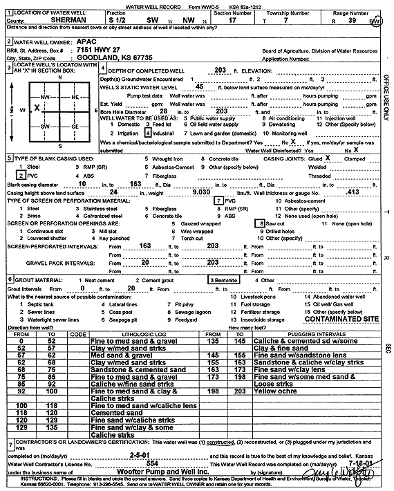
Specific Water Well Detail |
|
|
| Location Info | |||
| Owner: APAC | Status: Constructed | ||
| Location: T7S, R39W, Sec. 17, S2 SW NW | County: Sherman | ||
| Directions: | |||
| Latitude: 39.4463416 | Longitude: -101.7045884 | Datum NAD 27 | |
| Latitude: 39.4463394 | Longitude: -101.7050383 | Datum NAD 83 | |
| Longitude and latitude calculated by Survey from township-range-section-quarter calls. Only good to within the quarter call accuracy. | |||
| View well on interactive map | |||
| General Info | ||
| Well Depth: 203 ft. | Elevation: ft. | |
| Static Water Level: 45 ft. | Est. Yield: gpm. | |
| Comp. Date: 05-Feb-2001 | Well Use: Industrial | |
| DWR Applic. #: | Other ID: | |
| Links | |
| No Wizard information available. | |
| View info from WIMAS Water Right Data base... | |
| Driller Info | ||
| Driller: Jay C. Woofter Pump & Well, Inc. | License #: 554 | |
| Scanned Form | View scan |
|
Chemical Sample Submitted?:
Water Well disinfected?: | ||
| Casing Info | ||
| Casing Type:
Casing Joints: |
Diam: in. to ft | |
| Casing height above land surface: in
Casing Weight: lbs/ft Wall thickness or gauge no.: | ||
| Screen and Perforation Info | ||
| Screen Type: | Screen Openings: | |
| Screen-perforated intervals | From: ft to ft | |
| Gravel pack intervals | From: ft to ft | |
| Grout Info | ||
| Grout used: | From: to ft | |
| Source of Possible Contamination | ||
| Source: | ||
| Direction from well: | Distance: ft | |
| Lithologic Log
(Log data entered by KGS.) | ||
| From: 0 ft. to 52 ft. | Fine to medium sand and gravel | |
| From: 52 ft. to 57 ft. | Clay with medium sand streaks | |
| From: 57 ft. to 62 ft. | Medium sand and gravel | |
| From: 62 ft. to 68 ft. | Clay with medium sand streaks | |
| From: 68 ft. to 75 ft. | Sandstone and cemented sand | |
| From: 75 ft. to 85 ft. | Fine to medium sand and gravel | |
| From: 85 ft. to 92 ft. | Caliche with fine sand streaks | |
| From: 92 ft. to 100 ft. | Fine to medium sand and clay and caliche streaks | |
| From: 100 ft. to 118 ft. | Fine to medium sand with caliche lens | |
| From: 118 ft. to 120 ft. | Cemented sand | |
| From: 120 ft. to 129 ft. | Fine sand with caliche streaks | |
| From: 129 ft. to 135 ft. | Fine sand with clay and some caliche streaks | |
| From: 135 ft. to 145 ft. | Caliche and cemented sand with some clay and fine sand | |
| From: 145 ft. to 155 ft. | Fine sand with sandstone lens | |
| From: 155 ft. to 163 ft. | Sandstone and caliche with clay streaks | |
| From: 163 ft. to 173 ft. | Fine sand with clay lens | |
| From: 173 ft. to 198 ft. | Fine sand with some medium sand and loose streaks | |
| From: 198 ft. to 203 ft. | Yellow ochre | |