|
|
|
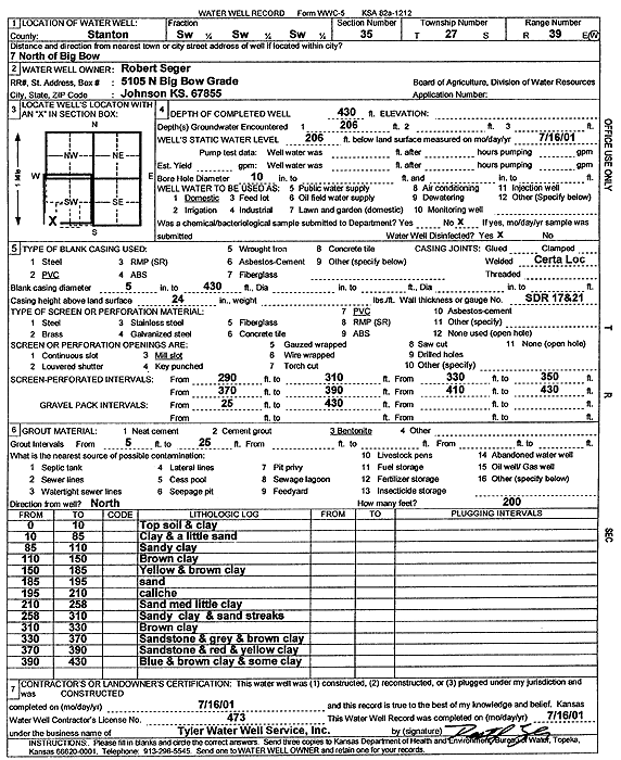
Specific Water Well Detail |
|
|
| Location Info | |||
| Owner: Seger, Robert | Status: Constructed | ||
| Location: T27S, R39W, Sec. 35, SW SW SW | County: Stanton | ||
| Directions: from Big Bow: 7 mi N | |||
| Latitude: 37.6503328 | Longitude: -101.5612734 | Datum NAD 27 | |
| Latitude: 37.6503496 | Longitude: -101.5617216 | Datum NAD 83 | |
| Longitude and latitude calculated by Survey from township-range-section-quarter calls. Only good to within the quarter call accuracy. | |||
| View well on interactive map | |||
| General Info | ||
| Well Depth: 430 ft. | Elevation: ft. | |
| Static Water Level: 206 ft. | Est. Yield: gpm. | |
| Comp. Date: 16-Jul-2001 | Well Use: Domestic | |
| DWR Applic. #: | Other ID: | |
| Driller Info | ||
| Driller: Destal Tyler Water Well Service | License #: 473 | |
| Scanned Form | View scan |
|
Chemical Sample Submitted?:
Water Well disinfected?: | ||
| Casing Info | ||
| Casing Type:
Casing Joints: |
Diam: in. to ft | |
| Casing height above land surface: in
Casing Weight: lbs/ft Wall thickness or gauge no.: | ||
| Screen and Perforation Info | ||
| Screen Type: | Screen Openings: | |
| Screen-perforated intervals | From: ft to ft | |
| Gravel pack intervals | From: ft to ft | |
| Grout Info | ||
| Grout used: | From: to ft | |
| Source of Possible Contamination | ||
| Source: | ||
| Direction from well: | Distance: ft | |
| Lithologic Log
(Log data entered by KGS.) | ||
| From: 0 ft. to 10 ft. | top soil and clay | |
| From: 10 ft. to 85 ft. | clay and a little sand | |
| From: 85 ft. to 110 ft. | sandy clay | |
| From: 110 ft. to 150 ft. | brown clay | |
| From: 150 ft. to 185 ft. | yellow and brown clay | |
| From: 185 ft. to 195 ft. | sand | |
| From: 195 ft. to 210 ft. | caliche | |
| From: 210 ft. to 258 ft. | sand medium little clay | |
| From: 258 ft. to 310 ft. | sandy clay and sand streaks | |
| From: 310 ft. to 330 ft. | brown clay | |
| From: 330 ft. to 370 ft. | sandstone and gray and brown clay | |
| From: 370 ft. to 390 ft. | sandstone and red and yellow clay | |
| From: 390 ft. to 430 ft. | blue and brown clay and some clay | |