|
|
|
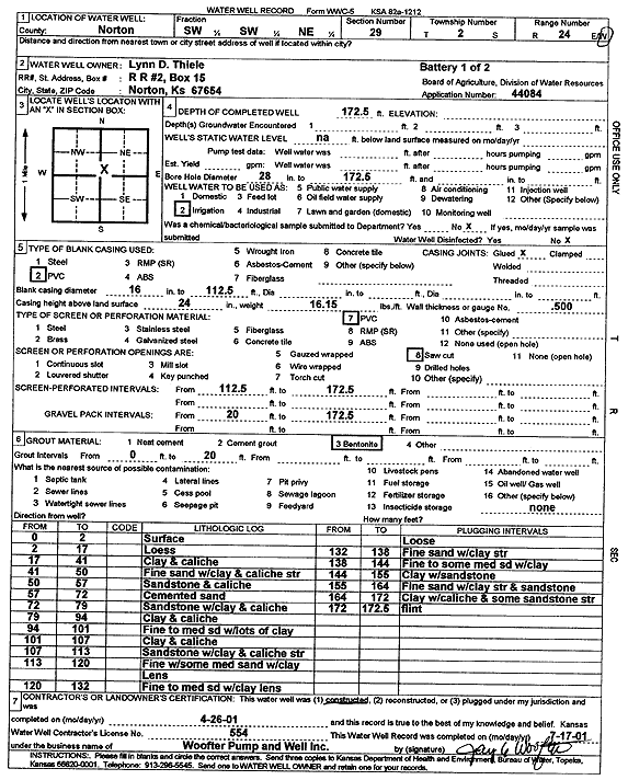
Specific Water Well Detail |
|
|
| Location Info | |||
| Owner: Thiele, Lynn D. | Status: Constructed | ||
| Location: T2S, R24W, Sec. 29, SW SW NE | County: Norton | ||
| Directions: | |||
| Latitude: 39.8504021 | Longitude: -100.0472174 | Datum NAD 27 | |
| Latitude: 39.8504073 | Longitude: -100.047625 | Datum NAD 83 | |
| Longitude and latitude calculated by Survey from township-range-section-quarter calls. Only good to within the quarter call accuracy. | |||
| View well on interactive map | |||
| General Info | ||
| Well Depth: 172.5 ft. | Elevation: ft. | |
| Static Water Level: ft. | Est. Yield: gpm. | |
| Comp. Date: 26-Apr-2001 | Well Use: Irrigation | |
| DWR Applic. #: 44084 | Other ID: battery 1 of 2 | |
| Links | |
| No Wizard information available. | |
| View info from WIMAS Water Right Data base... | |
| Driller Info | ||
| Driller: Jay C. Woofter Pump & Well, Inc. | License #: 554 | |
| Scanned Form | View scan |
|
Chemical Sample Submitted?:
Water Well disinfected?: | ||
| Casing Info | ||
| Casing Type:
Casing Joints: |
Diam: in. to ft | |
| Casing height above land surface: in
Casing Weight: lbs/ft Wall thickness or gauge no.: | ||
| Screen and Perforation Info | ||
| Screen Type: | Screen Openings: | |
| Screen-perforated intervals | From: ft to ft | |
| Gravel pack intervals | From: ft to ft | |
| Grout Info | ||
| Grout used: | From: to ft | |
| Source of Possible Contamination | ||
| Source: | ||
| Direction from well: | Distance: ft | |
| Lithologic Log
(Log data entered by KGS.) | ||
| From: 0 ft. to 2 ft. | surface | |
| From: 2 ft. to 17 ft. | loess | |
| From: 17 ft. to 41 ft. | clay and caliche | |
| From: 41 ft. to 50 ft. | fine sand with clay and caliche streaks | |
| From: 50 ft. to 57 ft. | sandstone and caliche | |
| From: 57 ft. to 72 ft. | cemented sand | |
| From: 72 ft. to 79 ft. | sandstone with clay and caliche | |
| From: 79 ft. to 94 ft. | clay and caliche | |
| From: 94 ft. to 101 ft. | fine to medium sand with lots of clay | |
| From: 101 ft. to 107 ft. | clay and caliche | |
| From: 107 ft. to 113 ft. | sandstone with clay and caliche streak | |
| From: 113 ft. to 120 ft. | fine with some medium sand with clay lens | |
| From: 120 ft. to 132 ft. | fine to medium sand with clay lens loose | |
| From: 132 ft. to 138 ft. | fine sand with clay streak | |
| From: 138 ft. to 144 ft. | fine to some medium sand with clay | |
| From: 144 ft. to 155 ft. | clay with sandstone | |
| From: 155 ft. to 164 ft. | fine sand with clay streak and sandstone | |
| From: 164 ft. to 172 ft. | clay with caliche and some sandstone streak | |
| From: 172 ft. to 172.5 ft. | flint | |