|
|
|
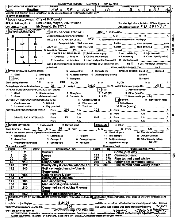
Specific Water Well Detail |
|
|
| Location Info | |||
| Owner: City of McDonald | Status: Constructed | ||
| Location: T3S, R36W, Sec. 16, SW SE SW | County: Rawlins | ||
| Directions: at ballfield | |||
| Latitude: 39.7866347 | Longitude: -101.366231 | Datum NAD 27 | |
| Latitude: 39.7866317 | Longitude: -101.366671 | Datum NAD 83 | |
| Longitude and latitude calculated by Survey from township-range-section-quarter calls. Only good to within the quarter call accuracy. | |||
| View well on interactive map | |||
| General Info | ||
| Well Depth: 300 ft. | Elevation: ft. | |
| Static Water Level: 212 ft. | Est. Yield: gpm. | |
| Comp. Date: 24-May-2001 | Well Use: Public Water Supply | |
| DWR Applic. #: PW 001570 | Other ID: | |
| Links | |
| No Wizard information available. | |
| View info from WIMAS Water Right Data base... | |
| Driller Info | ||
| Driller: Jay C. Woofter Pump & Well, Inc. | License #: 554 | |
| Scanned Form | View scan |
|
Chemical Sample Submitted?:
Water Well disinfected?: | ||
| Casing Info | ||
| Casing Type:
Casing Joints: |
Diam: in. to ft | |
| Casing height above land surface: in
Casing Weight: lbs/ft Wall thickness or gauge no.: | ||
| Screen and Perforation Info | ||
| Screen Type: | Screen Openings: | |
| Screen-perforated intervals | From: ft to ft | |
| Gravel pack intervals | From: ft to ft | |
| Grout Info | ||
| Grout used: | From: to ft | |
| Source of Possible Contamination | ||
| Source: | ||
| Direction from well: | Distance: ft | |
| Lithologic Log
(Log data entered by KGS.) | ||
| From: 0 ft. to 2 ft. | surface | |
| From: 2 ft. to 20 ft. | loess | |
| From: 20 ft. to 40 ft. | clay | |
| From: 40 ft. to 110 ft. | clay and caliche | |
| From: 110 ft. to 122 ft. | sandy clay and caliche with some sand | |
| From: 122 ft. to 143 ft. | soft cemented sand with clay and some sand | |
| From: 143 ft. to 154 ft. | caliche, chert, and clay | |
| From: 154 ft. to 171 ft. | sandy clay and caliche | |
| From: 171 ft. to 180 ft. | medium sand with clay | |
| From: 180 ft. to 187 ft. | medium sand and gravel, loose | |
| From: 187 ft. to 210 ft. | cemented sand with clay and some sand | |
| From: 210 ft. to 262 ft. | fine to medium sand with clay and some joint clay | |
| From: 262 ft. to 267 ft. | cemented sand | |
| From: 267 ft. to 279 ft. | fine to medium sand with clay | |
| From: 279 ft. to 285 ft. | fairly tight cemented sand | |
| From: 285 ft. to 300 ft. | fine to medium sand with clay lenses | |