|
|
|
Specific Water Well Detail |
|
|
| Location Info | |||
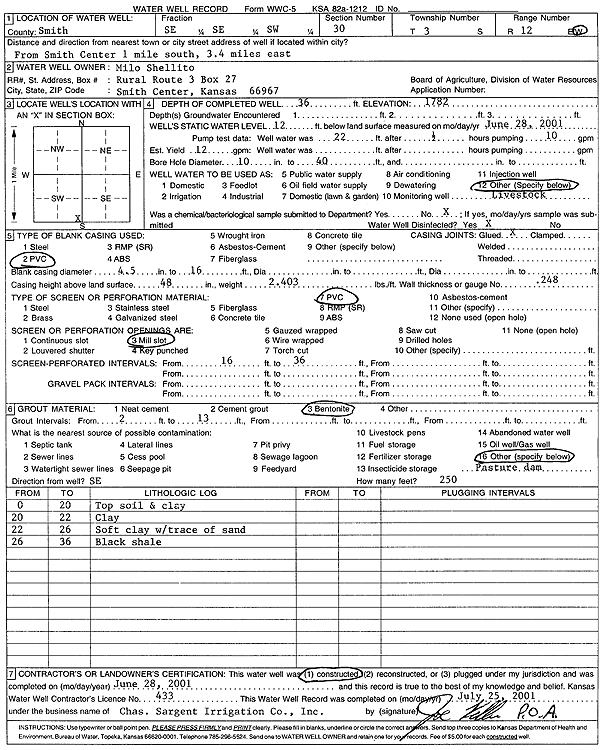
| Owner: Shellito, Milo | Status: Constructed | ||
| Location: T3S, R12W, Sec. 30, SE SE SW | County: Smith | ||
| Directions: from Smith Center: 1 mi S, 3.4 mi E | |||
| Latitude: 39.7571915 | Longitude: -98.7207702 | Datum NAD 27 | |
| Latitude: 39.7572033 | Longitude: -98.7211205 | Datum NAD 83 | |
| Longitude and latitude calculated by Survey from township-range-section-quarter calls. Only good to within the quarter call accuracy. | |||
| View well on interactive map | |||
| General Info | ||
| Well Depth: 36 ft. | Elevation: 1782 ft. | |
| Static Water Level: 12 ft. | Est. Yield: 12 gpm. | |
| Comp. Date: 28-Jun-2001 | Well Use: Domestic, Livestock | |
| DWR Applic. #: | Other ID: | |
| Driller Info | ||
| Driller: Chas. Sargent Irrigation Co., Inc. | License #: 433 | |
| Scanned Form | View scan |
|
Chemical Sample Submitted?:
Water Well disinfected?: | ||
| Casing Info | ||
| Casing Type:
Casing Joints: |
Diam: in. to ft | |
| Casing height above land surface: in
Casing Weight: lbs/ft Wall thickness or gauge no.: | ||
| Screen and Perforation Info | ||
| Screen Type: | Screen Openings: | |
| Screen-perforated intervals | From: ft to ft | |
| Gravel pack intervals | From: ft to ft | |
| Grout Info | ||
| Grout used: | From: to ft | |
| Source of Possible Contamination | ||
| Source: | ||
| Direction from well: | Distance: ft | |
| Lithologic Log
(Log data entered by KGS.) | ||
| From: 0 ft. to 20 ft. | top soil and clay | |
| From: 20 ft. to 22 ft. | clay | |
| From: 22 ft. to 26 ft. | soft clay with trace of clay | |
| From: 26 ft. to 36 ft. | black shale | |