|
|
|
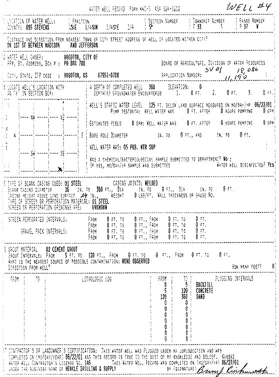
Specific Water Well Detail |
|
|
| Location Info | |||
| Owner: City of Hugoton | Status: Plugged | ||
| Location: T33S, R37W, Sec. 9, SE SW SE | County: Stevens | ||
| Directions: 1st St, between Madison and Jefferson | |||
| Latitude: 37.1852982 | Longitude: -101.3443367 | Datum NAD 27 | |
| Latitude: 37.1853229 | Longitude: -101.3447724 | Datum NAD 83 | |
| Longitude and latitude calculated by Survey from township-range-section-quarter calls. Only good to within the quarter call accuracy. | |||
| View well on interactive map | |||
| General Info | ||
| Well Depth: 360 ft. | Elevation: ft. | |
| Static Water Level: 125 ft. | Est. Yield: gpm. | |
| Comp. Date: 22-Jun-2001 | Well Use: Public Water Supply | |
| DWR Applic. #: 18086 | Other ID: Well 4 | |
| Links | |
| View info from Wizard Water Level Data base... | |
| View info from WIMAS Water Right Data base... | |
| Driller Info | ||
| Driller: Henkle Drilling & Supply Co. Inc. | License #: 145 | |
| Scanned Form | View scan |
| Casing Info | ||
|
Casing Type:
Diam: in. Casing height above land surface: in | ||
| Grout Info | ||
| Grout used: | From: to ft | |
| Source of Possible Contamination | ||
| Source: | ||
| Direction from well: | Distance: ft | |