|
|
|
Specific Water Well Detail |
|
|
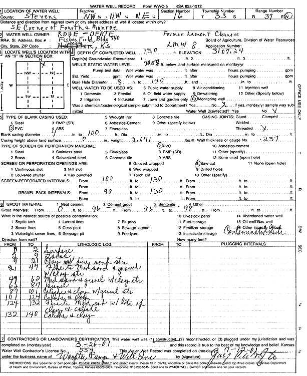
| Location Info | |||
| Owner: KDHE - DFRTE | Status: Constructed | ||
| Location: T33S, R37W, Sec. 16, NW NW NE | County: Stevens | ||
| Directions: SE corner of 4th and Monroe | |||
| Latitude: 37.183473 | Longitude: -101.3465897 | Datum NAD 27 | |
| Latitude: 37.1834977 | Longitude: -101.3470255 | Datum NAD 83 | |
| Longitude and latitude calculated by Survey from township-range-section-quarter calls. Only good to within the quarter call accuracy. | |||
| View well on interactive map | |||
| General Info | ||
| Well Depth: 130 ft. | Elevation: 3107.24 ft. | |
| Static Water Level: 90.58 ft. | Est. Yield: gpm. | |
| Comp. Date: 26-Mar-2001 | Well Use: Monitoring well/observation/piezometer | |
| DWR Applic. #: | Other ID: LMW 8 | |
| Driller Info | ||
| Driller: Jay C. Woofter Pump & Well, Inc. | License #: 554 | |
| Scanned Form | View scan |
|
Chemical Sample Submitted?:
Water Well disinfected?: | ||
| Casing Info | ||
| Casing Type:
Casing Joints: |
Diam: in. to ft | |
| Casing height above land surface: in
Casing Weight: lbs/ft Wall thickness or gauge no.: | ||
| Screen and Perforation Info | ||
| Screen Type: | Screen Openings: | |
| Screen-perforated intervals | From: ft to ft | |
| Gravel pack intervals | From: ft to ft | |
| Grout Info | ||
| Grout used: | From: to ft | |
| Source of Possible Contamination | ||
| Source: | ||
| Direction from well: | Distance: ft | |
| Lithologic Log
(Log data entered by KGS.) | ||
| From: 0 ft. to 2 ft. | surface | |
| From: 2 ft. to 9 ft. | loess | |
| From: 9 ft. to 21 ft. | clay with fine sand str | |
| From: 21 ft. to 47 ft. | fine to medium sand and gravel with clay str | |
| From: 47 ft. to 62 ft. | medium sand and gravel with clay str | |
| From: 62 ft. to 87 ft. | gravel | |
| From: 87 ft. to 101 ft. | caliche and clay with gravel str | |
| From: 101 ft. to 124 ft. | caliche and clay | |
| From: 124 ft. to 132 ft. | fine to medium sand with lots of clay and caliche | |
| From: 132 ft. to 140 ft. | caliche and clay | |