|
|
|
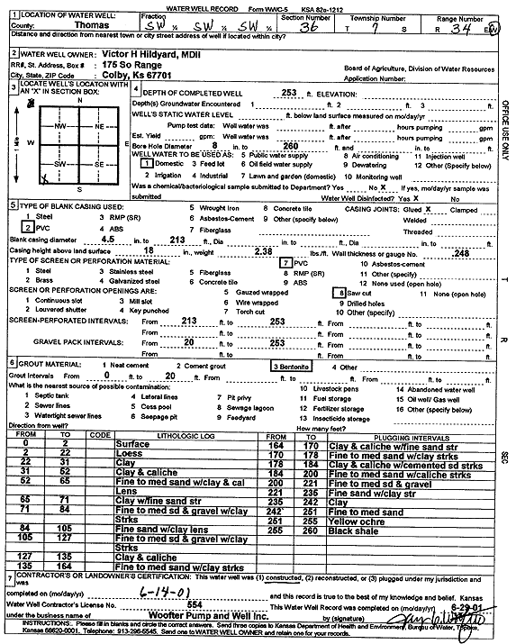
Specific Water Well Detail |
|
|
| Location Info | |||
| Owner: Hildyard MDII, Victor H. | Status: Constructed | ||
| Location: T7S, R34W, Sec. 36, SW SW SW | County: Thomas | ||
| Directions: | |||
| Latitude: 39.395244 | Longitude: -101.0719471 | Datum NAD 27 | |
| Latitude: 39.3952476 | Longitude: -101.0723806 | Datum NAD 83 | |
| Longitude and latitude calculated by Survey from township-range-section-quarter calls. Only good to within the quarter call accuracy. | |||
| View well on interactive map | |||
| General Info | ||
| Well Depth: 253 ft. | Elevation: ft. | |
| Static Water Level: 138 ft. | Est. Yield: gpm. | |
| Comp. Date: 14-Jun-2001 | Well Use: Domestic | |
| DWR Applic. #: | Other ID: | |
| Driller Info | ||
| Driller: Jay C. Woofter Pump & Well, Inc. | License #: 554 | |
| Scanned Form | View scan |
|
Chemical Sample Submitted?:
Water Well disinfected?: | ||
| Casing Info | ||
| Casing Type:
Casing Joints: |
Diam: in. to ft | |
| Casing height above land surface: in
Casing Weight: lbs/ft Wall thickness or gauge no.: | ||
| Screen and Perforation Info | ||
| Screen Type: | Screen Openings: | |
| Screen-perforated intervals | From: ft to ft | |
| Gravel pack intervals | From: ft to ft | |
| Grout Info | ||
| Grout used: | From: to ft | |
| Source of Possible Contamination | ||
| Source: | ||
| Direction from well: | Distance: ft | |
| Lithologic Log
(Log data entered by KGS.) | ||
| From: 0 ft. to 2 ft. | surface | |
| From: 2 ft. to 22 ft. | loess | |
| From: 22 ft. to 31 ft. | clay | |
| From: 31 ft. to 52 ft. | clay and caliche | |
| From: 52 ft. to 65 ft. | fine to medium sand with clay and caliche lens | |
| From: 65 ft. to 71 ft. | clay with fine sand streaks | |
| From: 71 ft. to 84 ft. | fine to medium sand and gravel with clay streaks | |
| From: 84 ft. to 105 ft. | fine sand with clay lens | |
| From: 105 ft. to 127 ft. | fine to medium sand and gravel with clay streaks | |
| From: 127 ft. to 135 ft. | clay and caliche | |
| From: 135 ft. to 164 ft. | fine to medium sand with clay streaks | |
| From: 164 ft. to 170 ft. | clay and caliche with fine sand streaks | |
| From: 170 ft. to 178 ft. | fine to medium sand with clay streaks | |
| From: 178 ft. to 184 ft. | clay and caliche with cemented sand streaks | |
| From: 184 ft. to 200 ft. | fine to medium sand with caliche streaks | |
| From: 200 ft. to 221 ft. | fine to medium sand and gravel | |
| From: 221 ft. to 235 ft. | fine sand with clay streaks | |
| From: 235 ft. to 242 ft. | clay | |
| From: 242 ft. to 251 ft. | fine to medium sand | |
| From: 251 ft. to 255 ft. | yellow ochre | |
| From: 255 ft. to 260 ft. | black shale | |