|
|
|
Specific Water Well Detail |
|
|
| Location Info | |||
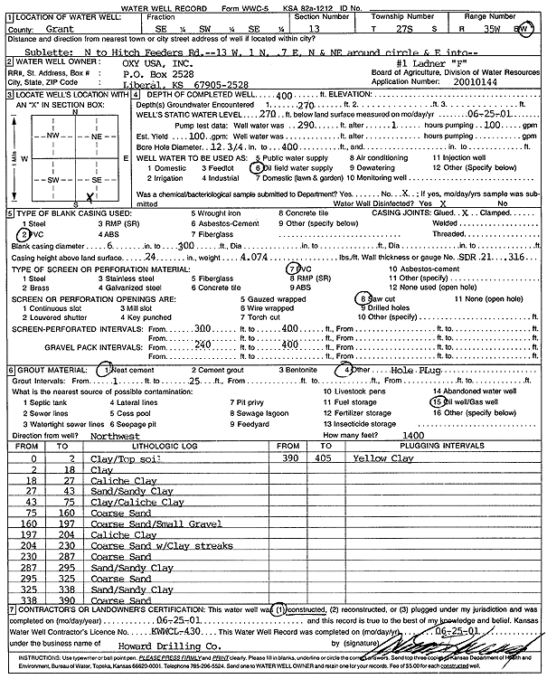
| Owner: Oxy USA, Inc. | Status: Constructed | ||
| Location: T27S, R35W, Sec. 13, SE SW SE | County: Grant | ||
| Directions: from Sublette: N to Hitch Feeders Rd, 13 mi W, 1 N, .7 E, NNE at circle, E | |||
| Latitude: 37.6936376 | Longitude: -101.0953446 | Datum NAD 27 | |
| Latitude: 37.6936599 | Longitude: -101.0957922 | Datum NAD 83 | |
| Longitude and latitude calculated by Survey from township-range-section-quarter calls. Only good to within the quarter call accuracy. | |||
| View well on interactive map | |||
| General Info | ||
| Well Depth: 400 ft. | Elevation: ft. | |
| Static Water Level: 270 ft. | Est. Yield: gpm. | |
| Comp. Date: 25-Jun-2001 | Well Use: Oil Field Water Supply | |
| DWR Applic. #: 20010144 | Other ID: | |
| Links | |
| No Wizard information available. | |
| View info from WIMAS Water Right Data base... | |
| Driller Info | ||
| Driller: Howard Drilling Company AG, LLC | License #: 430 | |
| Scanned Form | View scan |
|
Chemical Sample Submitted?:
Water Well disinfected?: | ||
| Casing Info | ||
| Casing Type:
Casing Joints: |
Diam: in. to ft | |
| Casing height above land surface: in
Casing Weight: lbs/ft Wall thickness or gauge no.: | ||
| Screen and Perforation Info | ||
| Screen Type: | Screen Openings: | |
| Screen-perforated intervals | From: ft to ft | |
| Gravel pack intervals | From: ft to ft | |
| Grout Info | ||
| Grout used: | From: to ft | |
| Source of Possible Contamination | ||
| Source: | ||
| Direction from well: | Distance: ft | |
| Lithologic Log
(Log data entered by KGS.) | ||
| From: 0 ft. to 2 ft. | Clay/Top soil | |
| From: 2 ft. to 18 ft. | Clay | |
| From: 18 ft. to 27 ft. | Caliche Clay | |
| From: 27 ft. to 43 ft. | Sand/Sandy Clay | |
| From: 43 ft. to 75 ft. | Clay/Caliche Clay | |
| From: 75 ft. to 160 ft. | Coarse Sand | |
| From: 160 ft. to 197 ft. | Coarse Sand/Small Gravel | |
| From: 197 ft. to 204 ft. | Caliche Clay | |
| From: 204 ft. to 230 ft. | Coarse Sand with Clay streaks | |
| From: 230 ft. to 287 ft. | Coarse Sand | |
| From: 287 ft. to 295 ft. | Sand/Sandy Clay | |
| From: 295 ft. to 325 ft. | Coarse Sand | |
| From: 325 ft. to 338 ft. | Sand/Sandy Clay | |
| From: 338 ft. to 390 ft. | Coarse Sand | |
| From: 390 ft. to 405 ft. | Yellow Clay | |