|
|
|
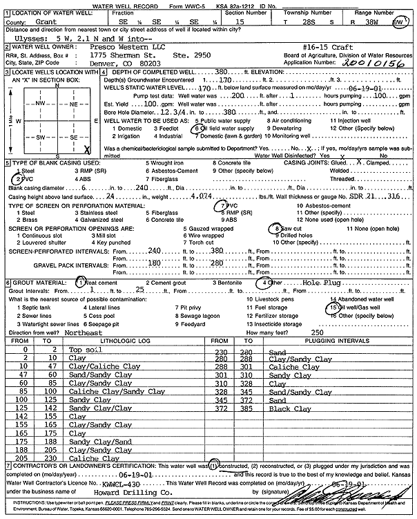
Specific Water Well Detail |
|
|
| Location Info | |||
| Owner: Presco Western LLC | Status: Constructed | ||
| Location: T28S, R38W, Sec. 15, SE SE SE | County: Grant | ||
| Directions: from Ulysses: 5 mi W, 2.1 N, W into site | |||
| Latitude: 37.6064023 | Longitude: -101.4540393 | Datum NAD 27 | |
| Latitude: 37.6064212 | Longitude: -101.4544867 | Datum NAD 83 | |
| Longitude and latitude calculated by Survey from township-range-section-quarter calls. Only good to within the quarter call accuracy. | |||
| View well on interactive map | |||
| General Info | ||
| Well Depth: 380 ft. | Elevation: ft. | |
| Static Water Level: 170 ft. | Est. Yield: gpm. | |
| Comp. Date: 19-Jun-2001 | Well Use: Oil Field Water Supply | |
| DWR Applic. #: 20010156 | Other ID: Craft 16-15 | |
| Links | |
| No Wizard information available. | |
| View info from WIMAS Water Right Data base... | |
| Driller Info | ||
| Driller: Howard Drilling Company AG, LLC | License #: 430 | |
| Scanned Form | View scan |
|
Chemical Sample Submitted?:
Water Well disinfected?: | ||
| Casing Info | ||
| Casing Type:
Casing Joints: |
Diam: in. to ft | |
| Casing height above land surface: in
Casing Weight: lbs/ft Wall thickness or gauge no.: | ||
| Screen and Perforation Info | ||
| Screen Type: | Screen Openings: | |
| Screen-perforated intervals | From: ft to ft | |
| Gravel pack intervals | From: ft to ft | |
| Grout Info | ||
| Grout used: | From: to ft | |
| Source of Possible Contamination | ||
| Source: | ||
| Direction from well: | Distance: ft | |
| Lithologic Log
(Log data entered by KGS.) | ||
| From: 0 ft. to 2 ft. | Top soil | |
| From: 2 ft. to 10 ft. | Clay | |
| From: 10 ft. to 47 ft. | Clay/Caliche Clay | |
| From: 47 ft. to 60 ft. | Sand/Sandy Clay | |
| From: 60 ft. to 85 ft. | Clay/Sandy Clay | |
| From: 85 ft. to 100 ft. | Caliche Clay/Sandy Clay | |
| From: 100 ft. to 125 ft. | Sandy Clay | |
| From: 125 ft. to 142 ft. | Sandy Clay/Clay | |
| From: 142 ft. to 155 ft. | Clay | |
| From: 155 ft. to 165 ft. | Clay/Sandy Clay | |
| From: 165 ft. to 175 ft. | Clay | |
| From: 175 ft. to 188 ft. | Sandy Clay/Sand | |
| From: 188 ft. to 205 ft. | Clay/Sandy Clay | |
| From: 205 ft. to 230 ft. | Caliche Clay | |
| From: 230 ft. to 280 ft. | Sand | |
| From: 280 ft. to 288 ft. | Clay/Sandy Clay | |
| From: 288 ft. to 301 ft. | Caliche Clay | |
| From: 301 ft. to 310 ft. | Sandy Clay | |
| From: 310 ft. to 328 ft. | Clay | |
| From: 328 ft. to 345 ft. | Sand/Sandy Clay | |
| From: 345 ft. to 372 ft. | Sand | |
| From: 372 ft. to 385 ft. | Black Clay | |