|
|
|
Specific Water Well Detail |
|
|
| Location Info | |||
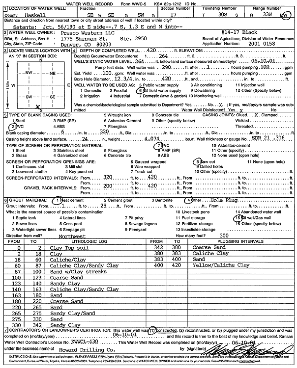
| Owner: Presco Western LLC | Status: Constructed | ||
| Location: T30S, R33W, Sec. 17, SE SE SW | County: Haskell | ||
| Directions: from 56 and 190 on E side: 0.7 mi S, 1.3 E, N into site | |||
| Latitude: 37.4322596 | Longitude: -100.953698 | Datum NAD 27 | |
| Latitude: 37.432284 | Longitude: -100.9541415 | Datum NAD 83 | |
| Longitude and latitude calculated by Survey from township-range-section-quarter calls. Only good to within the quarter call accuracy. | |||
| View well on interactive map | |||
| General Info | ||
| Well Depth: 420 ft. | Elevation: ft. | |
| Static Water Level: 264 ft. | Est. Yield: gpm. | |
| Comp. Date: 10-Jun-2001 | Well Use: Oil Field Water Supply | |
| DWR Applic. #: 20010158 | Other ID: Black 14-17 | |
| Links | |
| No Wizard information available. | |
| View info from WIMAS Water Right Data base... | |
| Driller Info | ||
| Driller: Howard Drilling Company AG, LLC | License #: 430 | |
| Scanned Form | View scan |
|
Chemical Sample Submitted?:
Water Well disinfected?: | ||
| Casing Info | ||
| Casing Type:
Casing Joints: |
Diam: in. to ft | |
| Casing height above land surface: in
Casing Weight: lbs/ft Wall thickness or gauge no.: | ||
| Screen and Perforation Info | ||
| Screen Type: | Screen Openings: | |
| Screen-perforated intervals | From: ft to ft | |
| Gravel pack intervals | From: ft to ft | |
| Grout Info | ||
| Grout used: | From: to ft | |
| Source of Possible Contamination | ||
| Source: | ||
| Direction from well: | Distance: ft | |
| Lithologic Log
(Log data entered by KGS.) | ||
| From: 0 ft. to 2 ft. | clay top soil | |
| From: 2 ft. to 18 ft. | clay | |
| From: 18 ft. to 60 ft. | caliche/clay | |
| From: 60 ft. to 87 ft. | caliche clay/sandy clay | |
| From: 87 ft. to 100 ft. | sand with clay streak | |
| From: 100 ft. to 123 ft. | coarse sand | |
| From: 123 ft. to 140 ft. | sandy clay | |
| From: 140 ft. to 163 ft. | caliche clay/sandy clay | |
| From: 163 ft. to 180 ft. | sand | |
| From: 180 ft. to 220 ft. | coarse sand | |
| From: 220 ft. to 265 ft. | sand | |
| From: 265 ft. to 275 ft. | sandy clay/sand | |
| From: 275 ft. to 330 ft. | sand | |
| From: 330 ft. to 342 ft. | sandy clay | |
| From: 342 ft. to 380 ft. | coarse sand | |
| From: 380 ft. to 383 ft. | caliche clay | |
| From: 383 ft. to 400 ft. | sand | |
| From: 400 ft. to 420 ft. | yellow/caliche clay | |