|
|
|
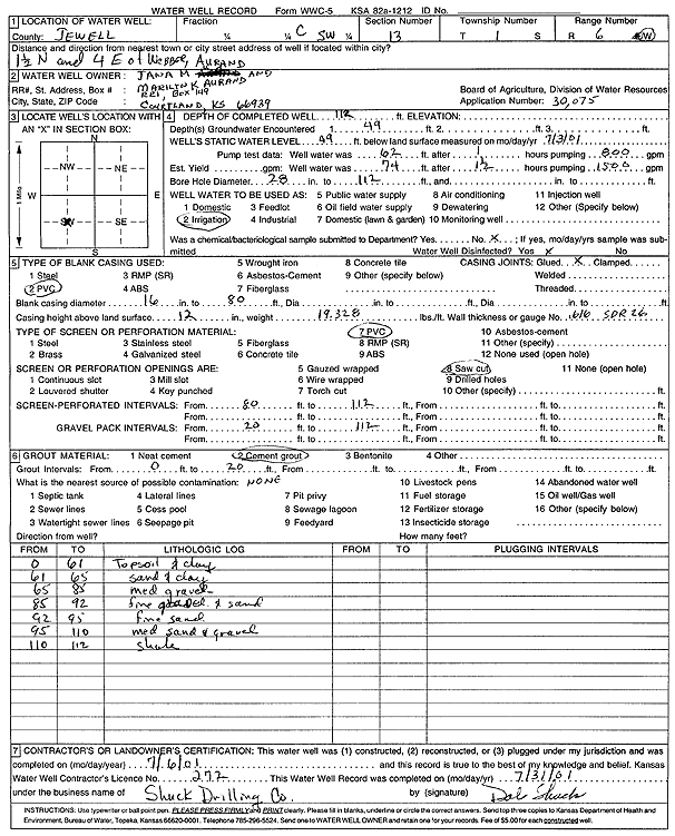
Specific Water Well Detail |
|
|
| Location Info | |||
| Owner: Aurand, Jana M. and Marilyn K. | Status: Constructed | ||
| Location: T1S, R6W, Sec. 13, C SW | County: Jewell | ||
| Directions: from Webber: 1.5 mi N, 4 mi E | |||
| Latitude: 39.9612493 | Longitude: -97.9457586 | Datum NAD 27 | |
| Latitude: 39.961262 | Longitude: -97.9460798 | Datum NAD 83 | |
| Longitude and latitude calculated by Survey from township-range-section-quarter calls. Only good to within the quarter call accuracy. | |||
| View well on interactive map | |||
| General Info | ||
| Well Depth: 112 ft. | Elevation: ft. | |
| Static Water Level: 49 ft. | Est. Yield: gpm. | |
| Comp. Date: 06-Jul-2001 | Well Use: Irrigation | |
| DWR Applic. #: 30075 | Other ID: | |
| Links | |
| No Wizard information available. | |
| View info from WIMAS Water Right Data base... | |
| Driller Info | ||
| Driller: Dale Shuck Drilling Co. | License #: 272 | |
| Scanned Form | View scan |
|
Chemical Sample Submitted?:
Water Well disinfected?: | ||
| Casing Info | ||
| Casing Type:
Casing Joints: |
Diam: in. to ft | |
| Casing height above land surface: in
Casing Weight: lbs/ft Wall thickness or gauge no.: | ||
| Screen and Perforation Info | ||
| Screen Type: | Screen Openings: | |
| Screen-perforated intervals | From: ft to ft | |
| Gravel pack intervals | From: ft to ft | |
| Grout Info | ||
| Grout used: | From: to ft | |
| Source of Possible Contamination | ||
| Source: | ||
| Direction from well: | Distance: ft | |
| Lithologic Log
(Log data entered by KGS.) | ||
| From: 0 ft. to 61 ft. | top soil and clay | |
| From: 61 ft. to 65 ft. | sand and clay | |
| From: 65 ft. to 85 ft. | medium gravel | |
| From: 85 ft. to 92 ft. | fine gravel and sand | |
| From: 92 ft. to 95 ft. | fine sand | |
| From: 95 ft. to 110 ft. | medium sand and gravel | |
| From: 110 ft. to 112 ft. | shale | |