|
|
|
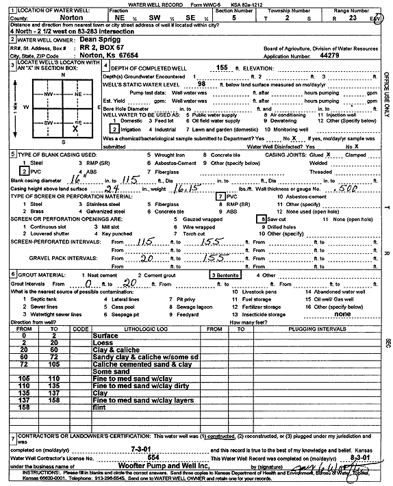
Specific Water Well Detail |
|
|
| Location Info | |||
| Owner: Sprigg, Dean | Status: Constructed | ||
| Location: T2S, R23W, Sec. 5, NE SW SE | County: Norton | ||
| Directions: from Hwy 83 and 283, 4 mi N and 2.5 mi W | |||
| Latitude: 39.9027499 | Longitude: -99.9319202 | Datum NAD 27 | |
| Latitude: 39.9027557 | Longitude: -99.9323225 | Datum NAD 83 | |
| Longitude and latitude calculated by Survey from township-range-section-quarter calls. Only good to within the quarter call accuracy. | |||
| View well on interactive map | |||
| General Info | ||
| Well Depth: 155 ft. | Elevation: ft. | |
| Static Water Level: 98 ft. | Est. Yield: gpm. | |
| Comp. Date: 03-Jul-2001 | Well Use: Irrigation | |
| DWR Applic. #: 44279 | Other ID: | |
| Links | |
| View info from Wizard Water Level Data base... | |
| View info from WIMAS Water Right Data base... | |
| Driller Info | ||
| Driller: Jay C. Woofter Pump & Well, Inc. | License #: 554 | |
| Scanned Form | View scan |
|
Chemical Sample Submitted?: No
Water Well disinfected?: No | ||
| Casing Info | ||
| Casing Type: PVC
Casing Joints: Glued |
Diam: 16 in. to 115 ft | |
| Casing height above land surface: 24 in
Casing Weight: 16.15 lbs/ft Wall thickness or gauge no.: .500 | ||
| Screen and Perforation Info | ||
| Screen Type: PVC | Screen Openings: Saw cut | |
| Screen-perforated intervals | From: 115 ft to 155 ft | |
| Gravel pack intervals | From: 20 ft to 155 ft | |
| Grout Info | ||
| Grout used: Bentonite | From: 0 to 20 ft | |
| Source of Possible Contamination | ||
| Source: none | ||
| Direction from well: | Distance: ft | |
| Lithologic Log
(Log data entered by KGS.) | ||
| From: 0 ft. to 2 ft. | surface | |
| From: 2 ft. to 20 ft. | loess | |
| From: 20 ft. to 60 ft. | clay and caliche | |
| From: 60 ft. to 72 ft. | sandy clay and caliche with some sand | |
| From: 72 ft. to 105 ft. | caliche cemented sand and clay, some sand | |
| From: 105 ft. to 110 ft. | fine to medium sand with clay | |
| From: 110 ft. to 135 ft. | fine to medium sand with clay dirty | |
| From: 135 ft. to 137 ft. | clay | |
| From: 137 ft. to 158 ft. | fine to medium sand with clay layers | |
| From: 158 ft. to ft. | flint | |