|
|
|
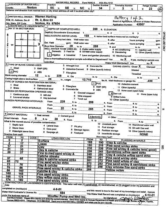
Specific Water Well Detail |
|
|
| Location Info | |||
| Owner: Harting, Warren | Status: Constructed | ||
| Location: T3S, R23W, Sec. 34, SE SE NE | County: Norton | ||
| Directions: (battery 1 of 2) | |||
| Latitude: 39.7485663 | Longitude: -99.8905019 | Datum NAD 27 | |
| Latitude: 39.7485716 | Longitude: -99.890902 | Datum NAD 83 | |
| Longitude and latitude calculated by Survey from township-range-section-quarter calls. Only good to within the quarter call accuracy. | |||
| View well on interactive map | |||
| General Info | ||
| Well Depth: 288 ft. | Elevation: ft. | |
| Static Water Level: 168 ft. | Est. Yield: gpm. | |
| Comp. Date: 09-Apr-2001 | Well Use: Irrigation | |
| DWR Applic. #: 43507 | Other ID: | |
| Links | |
| View info from Wizard Water Level Data base... | |
| View info from WIMAS Water Right Data base... | |
| Driller Info | ||
| Driller: Jay C. Woofter Pump & Well, Inc. | License #: 554 | |
| Scanned Form | View scan |
|
Chemical Sample Submitted?:
Water Well disinfected?: | ||
| Casing Info | ||
| Casing Type:
Casing Joints: |
Diam: in. to ft | |
| Casing height above land surface: in
Casing Weight: lbs/ft Wall thickness or gauge no.: | ||
| Screen and Perforation Info | ||
| Screen Type: | Screen Openings: | |
| Screen-perforated intervals | From: ft to ft | |
| Gravel pack intervals | From: ft to ft | |
| Grout Info | ||
| Grout used: | From: to ft | |
| Source of Possible Contamination | ||
| Source: | ||
| Direction from well: | Distance: ft | |
| Lithologic Log
(Log data entered by KGS.) | ||
| From: 0 ft. to 2 ft. | surface | |
| From: 2 ft. to 17 ft. | loess | |
| From: 17 ft. to 21 ft. | clay | |
| From: 21 ft. to 30 ft. | clay and caliche | |
| From: 30 ft. to 37 ft. | fine to medium sand with clay and caliche streaks | |
| From: 37 ft. to 65 ft. | clay and caliche with sand streaks | |
| From: 65 ft. to 72 ft. | fine sand with clay streaks | |
| From: 72 ft. to 76 ft. | clay and caliche | |
| From: 76 ft. to 86 ft. | fine sand with clay and caliche streaks | |
| From: 86 ft. to 160 ft. | caliche and clay | |
| From: 160 ft. to 165 ft. | fine sand with clay streaks | |
| From: 165 ft. to 174 ft. | clay with fine sand streaks | |
| From: 174 ft. to 180 ft. | fine sand with clay streaks | |
| From: 180 ft. to 190 ft. | clay and caliche | |
| From: 190 ft. to 210 ft. | fine sand with clay streaks | |
| From: 210 ft. to 230 ft. | fine sand with clay and caliche lens, good | |
| From: 230 ft. to 245 ft. | sandstone with fine sand streaks | |
| From: 245 ft. to 250 ft. | clay and caliche with fine streaks | |
| From: 250 ft. to 261 ft. | fine sand with clay streaks | |
| From: 261 ft. to 272 ft. | fine sand with lots of clay | |
| From: 272 ft. to 283 ft. | fine sand with clay and sandstone streaks | |
| From: 283 ft. to 288 ft. | clay with some fine sand streaks | |
| From: 288 ft. to ft. | yellow ochre | |