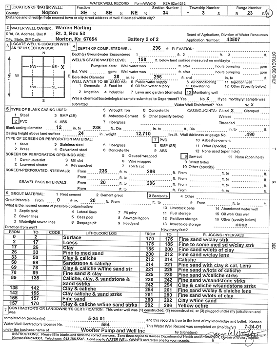
KGS Home Page Water Well Data base Specific Water Well Detail
Water Resources

Well T3S, R23W, Sec. 34, SE SE NE, Action: Constructed

Location Info
Owner: Harting, Warren Status: Constructed
Location: T3S, R23W, Sec. 34, SE SE NE County: Norton
Directions: (battery 2 of 2)
Latitude: 39.7485663 Longitude: -99.8905019 Datum NAD 27
Latitude: 39.7485716 Longitude: -99.890902 Datum NAD 83
Longitude and latitude calculated by Survey from township-range-section-quarter calls. Only good to within the quarter call accuracy.
View well on interactive map
General Info
Well Depth: 296 ft. Elevation: ft.
Static Water Level: 158 ft. Est. Yield: gpm.
Comp. Date: 24-May-2001 Well Use: Monitoring well/observation/piezometer
DWR Applic. #: 43507 Other ID:
Links
View info from Wizard Water Level Data base...
View info from WIMAS Water Right Data base...
Driller Info
Driller: Jay C. Woofter Pump & Well, Inc. License #: 554
Scanned Form
View form(s) on screen Download scan(s)
The download files contain one or more TIFF images compressed into a ZIP archive. Your browser may be already set up to decompress these files. The TIFFs are 300 dpi archival-quality scans of the WWC5 forms and can be viewed by software like Adobe PhotoShop.
Chemical Sample Submitted?:
Water Well disinfected?:
Casing Info
Casing Type:
Casing Joints:
Diam: in. to ft
Casing height above land surface: in
Casing Weight: lbs/ft
Wall thickness or gauge no.:
Screen and Perforation Info
Screen Type: Screen Openings:
Screen-perforated intervals From: ft to ft
Gravel pack intervals From: ft to ft
Grout Info
Grout used: From: to ft
Source of Possible Contamination
Source:
Direction from well: Distance: ft
Lithologic Log
(Log data entered by KGS.)
From: 0 ft. to 2 ft. surface
From: 2 ft. to 17 ft. loess
From: 17 ft. to 26 ft. clay
From: 26 ft. to 33 ft. fine to medium sand
From: 33 ft. to 50 ft. clay and caliche
From: 50 ft. to 69 ft. sandstone and caliche
From: 69 ft. to 78 ft. clay and caliche with fine sand streak
From: 78 ft. to 89 ft. fine sand and clay
From: 89 ft. to 135 ft. caliche, clay, and sandstone and sand streaks
From: 135 ft. to 142 ft. clay and caliche
From: 142 ft. to 155 ft. clay, caliche, and sand streaks
From: 155 ft. to 157 ft. fine sand
From: 157 ft. to 170 ft. clay and caliche with fine sand streaks
From: 170 ft. to 175 ft. fine sand with clay streak
From: 175 ft. to 185 ft. fine to some medium sand with clay streak
From: 185 ft. to 200 ft. fine sand with lots of clay
From: 200 ft. to 212 ft. fine sand with clay lens
From: 212 ft. to 214 ft. caliche
From: 214 ft. to 221 ft. fine sand with clay and caliche lens
From: 221 ft. to 225 ft. fine sand with lots of caliche
From: 225 ft. to 230 ft. fine sand with caliche streaks
From: 230 ft. to 242 ft. fine sand with sandstone streaks
From: 242 ft. to 254 ft. clay and caliche with sandstone streaks
From: 254 ft. to 261 ft. fine sand with clay and caliche lens
From: 261 ft. to 280 ft. fine sand with lots of clay
From: 280 ft. to 292 ft. clay with fine sand
From: 292 ft. to 296 ft. yellow ochre

Kansas Geological Survey
Comments to kgs-webadmin@ku.edu
URL=http://www.kgs.ku.edu/Magellan/WaterWell/index.html
Display Programs Updated January 2, 2025
Data added continuously.