|
|
|
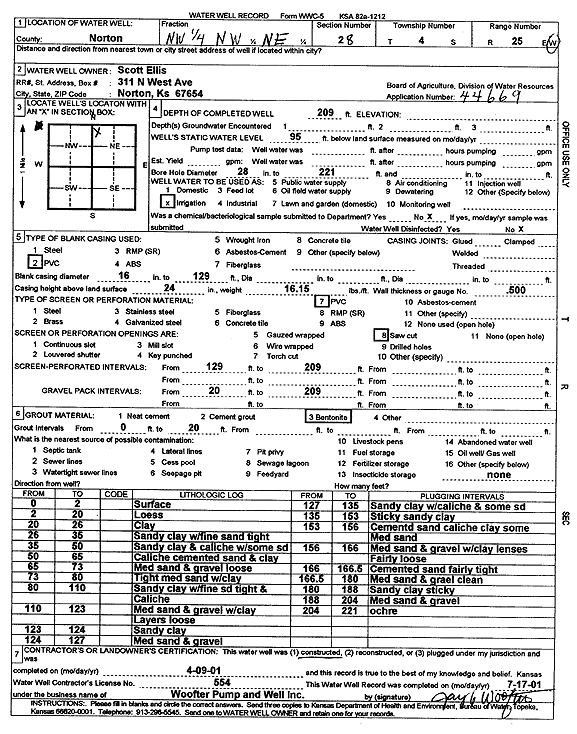
Specific Water Well Detail |
|
|
| Location Info | |||
| Owner: Ellis, Scott | Status: Constructed | ||
| Location: T4S, R25W, Sec. 28, NW NW NE | County: Norton | ||
| Directions: | |||
| Latitude: 39.6817621 | Longitude: -100.1415618 | Datum NAD 27 | |
| Latitude: 39.6817665 | Longitude: -100.1419731 | Datum NAD 83 | |
| Longitude and latitude calculated by Survey from township-range-section-quarter calls. Only good to within the quarter call accuracy. | |||
| View well on interactive map | |||
| General Info | ||
| Well Depth: 209 ft. | Elevation: ft. | |
| Static Water Level: 95 ft. | Est. Yield: gpm. | |
| Comp. Date: 09-Apr-2001 | Well Use: Irrigation | |
| DWR Applic. #: 44669 | Other ID: | |
| Links | |
| No Wizard information available. | |
| View info from WIMAS Water Right Data base... | |
| Driller Info | ||
| Driller: Jay C. Woofter Pump & Well, Inc. | License #: 554 | |
| Scanned Form | View scan |
|
Chemical Sample Submitted?:
Water Well disinfected?: | ||
| Casing Info | ||
| Casing Type:
Casing Joints: |
Diam: in. to ft | |
| Casing height above land surface: in
Casing Weight: lbs/ft Wall thickness or gauge no.: | ||
| Screen and Perforation Info | ||
| Screen Type: | Screen Openings: | |
| Screen-perforated intervals | From: ft to ft | |
| Gravel pack intervals | From: ft to ft | |
| Grout Info | ||
| Grout used: | From: to ft | |
| Source of Possible Contamination | ||
| Source: | ||
| Direction from well: | Distance: ft | |
| Lithologic Log
(Log data entered by KGS.) | ||
| From: 0 ft. to 2 ft. | surface | |
| From: 2 ft. to 20 ft. | loess | |
| From: 20 ft. to 26 ft. | clay | |
| From: 26 ft. to 35 ft. | sandy clay with fine sand, tight | |
| From: 35 ft. to 50 ft. | sandy clay and caliche with some sand | |
| From: 50 ft. to 65 ft. | caliche, cemented sand, and clay | |
| From: 65 ft. to 73 ft. | medium sand and gravel, loose | |
| From: 73 ft. to 80 ft. | tight medium sand with clay | |
| From: 80 ft. to 110 ft. | sandy clay with fine sand, tight, and caliche | |
| From: 110 ft. to 123 ft. | medium sand and gravel with clay layers, loose | |
| From: 123 ft. to 124 ft. | sandy clay | |
| From: 124 ft. to 127 ft. | medium sand and gravel | |
| From: 127 ft. to 135 ft. | sandy clay with caliche and some sand | |
| From: 135 ft. to 153 ft. | sticky sandy clay | |
| From: 153 ft. to 156 ft. | cemented sand, caliche, clay, some medium sand | |
| From: 156 ft. to 166 ft. | medium sand and gravel with clay lenses, fairly loose | |
| From: 166 ft. to 166.5 ft. | cemented sand, fairly tight | |
| From: 166.5 ft. to 180 ft. | medium sand and gravel, clean | |
| From: 180 ft. to 188 ft. | sandy clay, sticky | |
| From: 188 ft. to 204 ft. | medium sand and gravel | |
| From: 204 ft. to 221 ft. | ochre | |