|
|
|
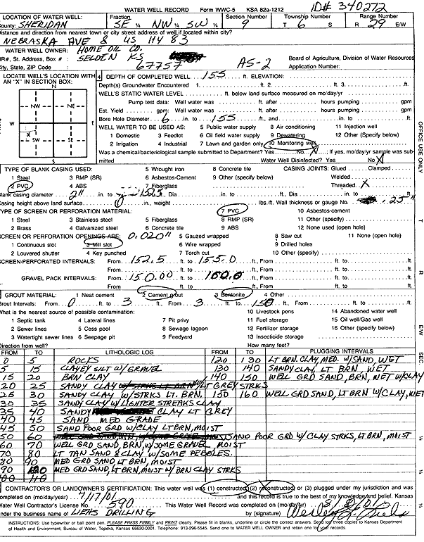
Specific Water Well Detail |
|
|
| Location Info | |||
| Owner: Home Oil Company | Status: Constructed | ||
| Location: T6S, R29W, Sec. 9, SE NW SW | County: Sheridan | ||
| Directions: Nebraska Ave and US Hwy 83 (tag 340272) | |||
| Latitude: 39.5431386 | Longitude: -100.5677677 | Datum NAD 27 | |
| Latitude: 39.5431426 | Longitude: -100.5681896 | Datum NAD 83 | |
| Longitude and latitude calculated by Survey from township-range-section-quarter calls. Only good to within the quarter call accuracy. | |||
| View well on interactive map | |||
| General Info | ||
| Well Depth: 155 ft. | Elevation: ft. | |
| Static Water Level: ft. | Est. Yield: gpm. | |
| Comp. Date: 17-Jul-2001 | Well Use: Environmental Remediation, Air Sparge | |
| DWR Applic. #: | Other ID: AS 2 | |
| Driller Info | ||
| Driller: Wesley G. Liehs Drilling, Inc. | License #: 590 | |
| Scanned Form | View scan |
|
Chemical Sample Submitted?:
Water Well disinfected?: | ||
| Casing Info | ||
| Casing Type:
Casing Joints: |
Diam: in. to ft | |
| Casing height above land surface: in
Casing Weight: lbs/ft Wall thickness or gauge no.: | ||
| Screen and Perforation Info | ||
| Screen Type: | Screen Openings: | |
| Screen-perforated intervals | From: ft to ft | |
| Gravel pack intervals | From: ft to ft | |
| Grout Info | ||
| Grout used: | From: to ft | |
| Source of Possible Contamination | ||
| Source: | ||
| Direction from well: | Distance: ft | |
| Lithologic Log
(Log data entered by KGS.) | ||
| From: 0 ft. to 5 ft. | Rocks | |
| From: 5 ft. to 15 ft. | Clayey silt with gravel | |
| From: 15 ft. to 20 ft. | Brown sand | |
| From: 20 ft. to 25 ft. | Sandy clay with light gray streaks | |
| From: 25 ft. to 30 ft. | Sandy clay with streaks lit brown | |
| From: 30 ft. to 35 ft. | Sandy clay with lighter streaks clay | |
| From: 35 ft. to 40 ft. | Sandy clay light gray | |
| From: 40 ft. to 45 ft. | Sand medium grade | |
| From: 45 ft. to 50 ft. | Sand poor grade with clay light brown moist | |
| From: 50 ft. to 60 ft. | Sand poor grade | |
| From: 60 ft. to 70 ft. | Well grade sand, brown, with some gravel, moist | |
| From: 70 ft. to 80 ft. | Light tan sand, brown with some gravel, moist | |
| From: 80 ft. to 90 ft. | Medium grade sand, light brown moist | |
| From: 90 ft. to 120 ft. | Medium grade sand, light brown moist with brown clay streaks | |
| From: 120 ft. to 130 ft. | Light brown clay, medium with sand wet | |
| From: 130 ft. to 140 ft. | Sandy clay, light brown, wet | |
| From: 140 ft. to 150 ft. | Well grade sand, brown, wet with clay | |
| From: 150 ft. to 160 ft. | Well grade sand, light brown with clay wet | |