|
|
|
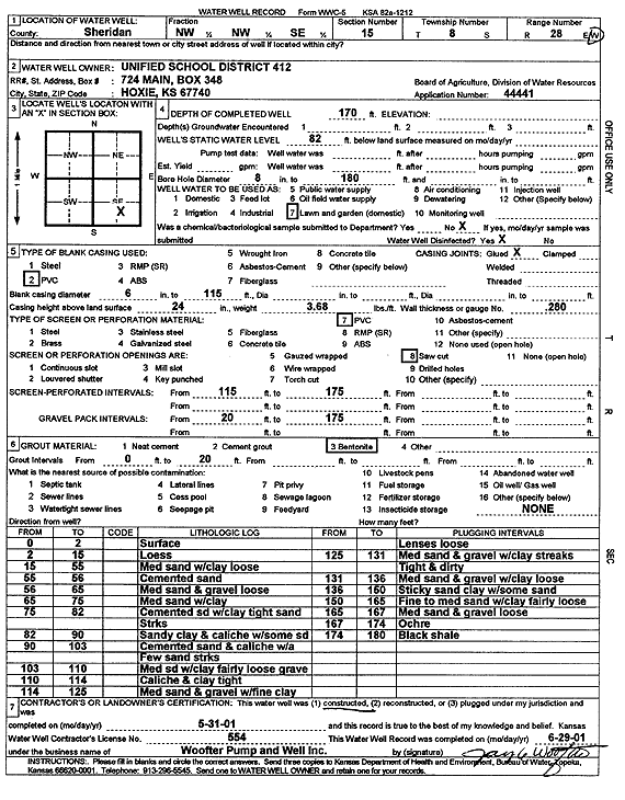
Specific Water Well Detail |
|
|
| Location Info | |||
| Owner: Unified School District 412 | Status: Constructed | ||
| Location: T8S, R28W, Sec. 15, NW NW SE | County: Sheridan | ||
| Directions: | |||
| Latitude: 39.3568923 | Longitude: -100.4311714 | Datum NAD 27 | |
| Latitude: 39.3568971 | Longitude: -100.4315893 | Datum NAD 83 | |
| Longitude and latitude calculated by Survey from township-range-section-quarter calls. Only good to within the quarter call accuracy. | |||
| View well on interactive map | |||
| General Info | ||
| Well Depth: 170 ft. | Elevation: ft. | |
| Static Water Level: 82 ft. | Est. Yield: gpm. | |
| Comp. Date: 31-May-2001 | Well Use: Domestic, Lawn and Garden | |
| DWR Applic. #: 44441 | Other ID: | |
| Links | |
| No Wizard information available. | |
| View info from WIMAS Water Right Data base... | |
| Driller Info | ||
| Driller: Jay C. Woofter Pump & Well, Inc. | License #: 554 | |
| Scanned Form | View scan |
|
Chemical Sample Submitted?:
Water Well disinfected?: | ||
| Casing Info | ||
| Casing Type:
Casing Joints: |
Diam: in. to ft | |
| Casing height above land surface: in
Casing Weight: lbs/ft Wall thickness or gauge no.: | ||
| Screen and Perforation Info | ||
| Screen Type: | Screen Openings: | |
| Screen-perforated intervals | From: ft to ft | |
| Gravel pack intervals | From: ft to ft | |
| Grout Info | ||
| Grout used: | From: to ft | |
| Source of Possible Contamination | ||
| Source: | ||
| Direction from well: | Distance: ft | |
| Lithologic Log
(Log data entered by KGS.) | ||
| From: 0 ft. to 2 ft. | Surface | |
| From: 2 ft. to 15 ft. | Loess | |
| From: 15 ft. to 55 ft. | Medium sand with clay loose | |
| From: 55 ft. to 56 ft. | Cemented sand | |
| From: 56 ft. to 65 ft. | Medium sand and gravel loose | |
| From: 65 ft. to 75 ft. | Medium sand with clay | |
| From: 75 ft. to 82 ft. | Cemented sand with clay tight sand streaks | |
| From: 82 ft. to 90 ft. | Sandy clay and caliche with some sand | |
| From: 90 ft. to 103 ft. | Cemented sand and caliche with a few sand streaks | |
| From: 103 ft. to 110 ft. | Medium sand with clay fairly loose gravel | |
| From: 110 ft. to 114 ft. | Caliche and clay tight | |
| From: 114 ft. to 125 ft. | Medium sand and gravel with fine clay Lenses loose | |
| From: 125 ft. to 131 ft. | Medium sand and gravel with clay streaks tight and dirty | |
| From: 131 ft. to 136 ft. | Medium sand and gravel with clay loose | |
| From: 136 ft. to 150 ft. | Sticky sand clay with some sand | |
| From: 150 ft. to 165 ft. | Fine to medium sand with clay fairly loose | |
| From: 165 ft. to 167 ft. | Medium sand and gravel loose | |
| From: 167 ft. to 174 ft. | Ochre | |
| From: 174 ft. to 180 ft. | Black shale | |