|
|
|
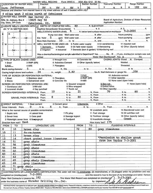
Specific Water Well Detail |
|
|
| Location Info | |||
| Owner: Harvey, Sam Jr. | Status: Constructed | ||
| Location: T9S, R18E, Sec. 26, NW NW NW | County: Jefferson | ||
| Directions: from Oskaloosa: 4 mi W, 2 mi N | |||
| Latitude: 39.2438646 | Longitude: -95.3838376 | Datum NAD 27 | |
| Latitude: 39.2438633 | Longitude: -95.3840886 | Datum NAD 83 | |
| Longitude and latitude calculated by Survey from township-range-section-quarter calls. Only good to within the quarter call accuracy. | |||
| View well on interactive map | |||
| General Info | ||
| Well Depth: 80 ft. | Elevation: ft. | |
| Static Water Level: 6 ft. | Est. Yield: 5 gpm. | |
| Comp. Date: 02-Jul-2001 | Well Use: Domestic | |
| DWR Applic. #: | Other ID: | |
| Driller Info | ||
| Driller: Strader Drilling Co., Inc. | License #: 182 | |
| Scanned Form | View scan |
|
Chemical Sample Submitted?:
Water Well disinfected?: | ||
| Casing Info | ||
| Casing Type:
Casing Joints: |
Diam: in. to ft | |
| Casing height above land surface: in
Casing Weight: lbs/ft Wall thickness or gauge no.: | ||
| Screen and Perforation Info | ||
| Screen Type: | Screen Openings: | |
| Screen-perforated intervals | From: ft to ft | |
| Gravel pack intervals | From: ft to ft | |
| Grout Info | ||
| Grout used: | From: to ft | |
| Source of Possible Contamination | ||
| Source: | ||
| Direction from well: | Distance: ft | |
| Lithologic Log
(Log data entered by KGS.) | ||
| From: 0 ft. to 10 ft. | brown clay | |
| From: 10 ft. to 11 ft. | fine sand, coarse sand, brown | |
| From: 11 ft. to 13 ft. | brown clay | |
| From: 13 ft. to 14 ft. | chert gravel, loose limestone | |
| From: 14 ft. to 51 ft. | gray shale | |
| From: 51 ft. to 56 ft. | gray limestone | |
| From: 56 ft. to 59 ft. | gray shale | |
| From: 59 ft. to 60 ft. | gray limestone | |
| From: 60 ft. to 61 ft. | gray shale | |
| From: 61 ft. to 62 ft. | gray limestone | |
| From: 62 ft. to 65 ft. | gray shaley limestone | |
| From: 65 ft. to 69 ft. | gray limestone | |
| From: 69 ft. to 71 ft. | gray shale | |
| From: 71 ft. to 72 ft. | black shale | |
| From: 72 ft. to 80 ft. | gray limestone | |