|
|
|
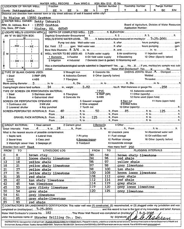
Specific Water Well Detail |
|
|
| Location Info | |||
| Owner: Uskurait, Betty | Status: Constructed | ||
| Location: T6S, R9E, Sec. 27, SE SE SW | County: Pottawatomie | ||
| Directions: 13550 Gratton, Blaine | |||
| Latitude: 39.4943149 | Longitude: -96.3989983 | Datum NAD 27 | |
| Latitude: 39.4943113 | Longitude: -96.3992806 | Datum NAD 83 | |
| Longitude and latitude calculated by Survey from township-range-section-quarter calls. Only good to within the quarter call accuracy. | |||
| View well on interactive map | |||
| General Info | ||
| Well Depth: 125 ft. | Elevation: ft. | |
| Static Water Level: 70 ft. | Est. Yield: 12 gpm. | |
| Comp. Date: 25-Jul-2001 | Well Use: Domestic | |
| DWR Applic. #: | Other ID: | |
| Driller Info | ||
| Driller: Strader Drilling Co., Inc. | License #: 182 | |
| Scanned Form | View scan |
|
Chemical Sample Submitted?:
Water Well disinfected?: | ||
| Casing Info | ||
| Casing Type:
Casing Joints: |
Diam: in. to ft | |
| Casing height above land surface: in
Casing Weight: lbs/ft Wall thickness or gauge no.: | ||
| Screen and Perforation Info | ||
| Screen Type: | Screen Openings: | |
| Screen-perforated intervals | From: ft to ft | |
| Gravel pack intervals | From: ft to ft | |
| Grout Info | ||
| Grout used: | From: to ft | |
| Source of Possible Contamination | ||
| Source: | ||
| Direction from well: | Distance: ft | |
| Lithologic Log
(Log data entered by KGS.) | ||
| From: 0 ft. to 8 ft. | brown clay | |
| From: 8 ft. to 12 ft. | loose cherty limestone | |
| From: 12 ft. to 18 ft. | yellow shale | |
| From: 18 ft. to 21 ft. | yellow shaley limestone | |
| From: 21 ft. to 27 ft. | yellow shale | |
| From: 27 ft. to 31 ft. | yellow shaley limestone | |
| From: 31 ft. to 35 ft. | red shale | |
| From: 35 ft. to 42 ft. | tan shaley limestone | |
| From: 42 ft. to 45 ft. | tan limestone | |
| From: 45 ft. to 50 ft. | gray flinty limestone | |
| From: 50 ft. to 54 ft. | gray shale | |
| From: 54 ft. to 61 ft. | gray limestone | |
| From: 61 ft. to 85 ft. | gray shale, limestone | |
| From: 85 ft. to 90 ft. | red shale | |
| From: 90 ft. to 94 ft. | brown shaley limestone | |
| From: 94 ft. to 96 ft. | red shale | |
| From: 96 ft. to 97 ft. | yellow shale | |
| From: 97 ft. to 98 ft. | gray limestone | |
| From: 98 ft. to 100 ft. | tan shale | |
| From: 100 ft. to 108 ft. | brown loose limestone | |
| From: 108 ft. to 112 ft. | gray shale | |
| From: 112 ft. to 114 ft. | red shale | |
| From: 114 ft. to 119 ft. | gray shale | |
| From: 119 ft. to 120 ft. | gray loose limestone | |
| From: 120 ft. to 125 ft. | gray limestone | |