|
|
|
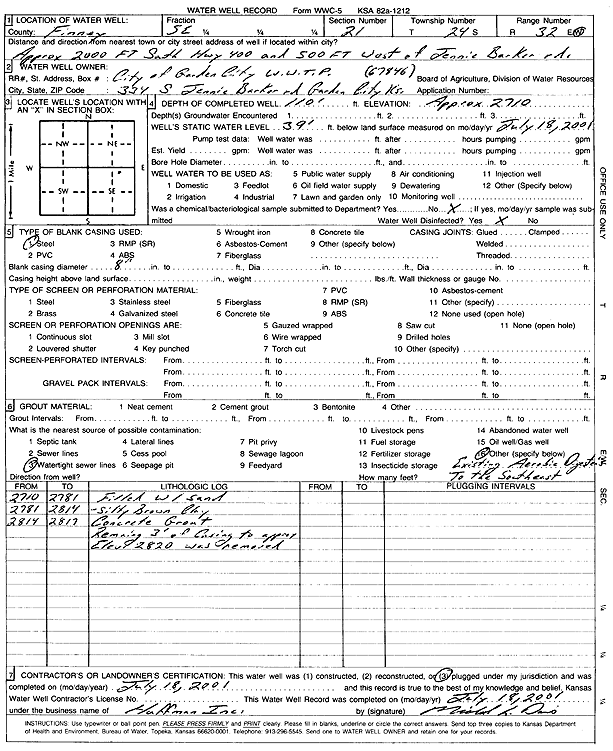
Specific Water Well Detail |
|
|
| Location Info | |||
| Owner: City of Gardern City WWTP | Status: Plugged | ||
| Location: T24S, R32W, Sec. 21, SE | County: Finney | ||
| Directions: 2000' S of Hwy 400, 500' W of Jennie Barker Rd | |||
| Latitude: 37.9495313 | Longitude: -100.833078 | Datum NAD 27 | |
| Latitude: 37.9495542 | Longitude: -100.8335163 | Datum NAD 83 | |
| Longitude and latitude calculated by Survey from township-range-section-quarter calls. Only good to within the quarter call accuracy. | |||
| View well on interactive map | |||
| General Info | ||
| Well Depth: 110 ft. | Elevation: 2710 ft. | |
| Static Water Level: 39 ft. | Est. Yield: gpm. | |
| Comp. Date: 18-Jul-2001 | Well Use: (unstated)/abandoned | |
| DWR Applic. #: | Other ID: | |
| Driller Info | ||
| Driller: Huffman, Inc. | License #: | |
| Scanned Form | View scan |
| Casing Info | ||
|
Casing Type:
Diam: in. Casing height above land surface: in | ||
| Grout Info | ||
| Grout used: | From: to ft | |
| Source of Possible Contamination | ||
| Source: | ||
| Direction from well: | Distance: ft | |