|
|
|
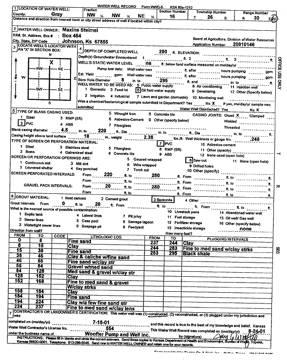
Specific Water Well Detail |
|
|
| Location Info | |||
| Owner: Steimel, Maxine | Status: Constructed | ||
| Location: T26S, R30W, Sec. 16, NW NW NE | County: Gray | ||
| Directions: | |||
| Latitude: 37.7940625 | Longitude: -100.6045655 | Datum NAD 27 | |
| Latitude: 37.7940853 | Longitude: -100.6049971 | Datum NAD 83 | |
| Longitude and latitude calculated by Survey from township-range-section-quarter calls. Only good to within the quarter call accuracy. | |||
| View well on interactive map | |||
| General Info | ||
| Well Depth: 280 ft. | Elevation: ft. | |
| Static Water Level: ft. | Est. Yield: gpm. | |
| Comp. Date: 18-Jul-2001 | Well Use: Oil Field Water Supply | |
| DWR Applic. #: 20010146 | Other ID: | |
| Links | |
| No Wizard information available. | |
| View info from WIMAS Water Right Data base... | |
| Driller Info | ||
| Driller: Jay C. Woofter Pump & Well, Inc. | License #: 554 | |
| Scanned Form | View scan |
|
Chemical Sample Submitted?:
Water Well disinfected?: | ||
| Casing Info | ||
| Casing Type:
Casing Joints: |
Diam: in. to ft | |
| Casing height above land surface: in
Casing Weight: lbs/ft Wall thickness or gauge no.: | ||
| Screen and Perforation Info | ||
| Screen Type: | Screen Openings: | |
| Screen-perforated intervals | From: ft to ft | |
| Gravel pack intervals | From: ft to ft | |
| Grout Info | ||
| Grout used: | From: to ft | |
| Source of Possible Contamination | ||
| Source: | ||
| Direction from well: | Distance: ft | |
| Lithologic Log
(Log data entered by KGS.) | ||
| From: 0 ft. to 8 ft. | Fine sand | |
| From: 8 ft. to 15 ft. | Clay | |
| From: 15 ft. to 38 ft. | Fine sand | |
| From: 38 ft. to 46 ft. | Clay and caliche with fine sand | |
| From: 46 ft. to 55 ft. | Fine sand with clay streak | |
| From: 55 ft. to 84 ft. | Gravel with medium sand | |
| From: 84 ft. to 128 ft. | Medium sand and gravel with clay streak | |
| From: 128 ft. to 152 ft. | Clay | |
| From: 152 ft. to 168 ft. | Fine to medium sand and gravel with clay streak | |
| From: 168 ft. to 184 ft. | Clay | |
| From: 184 ft. to 194 ft. | Fine sand | |
| From: 194 ft. to 224 ft. | Clay with a few fine sand streak | |
| From: 224 ft. to 237 ft. | Fine to medium sand with clay lens | |
| From: 237 ft. to 244 ft. | Clay | |
| From: 244 ft. to 283 ft. | Fine to medium sand with clay streaks | |
| From: 283 ft. to 295 ft. | Black shale | |