|
|
|
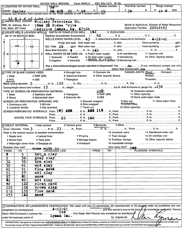
Specific Water Well Detail |
|
|
| Location Info | |||
| Owner: Woolsey Petroleum Corp. | Status: Constructed | ||
| Location: T30S, R14W, Sec. 14, NW SE SW | County: Barber | ||
| Directions: from Lake City: 5.5 mi N, .5 mi W | |||
| Latitude: 37.429695 | Longitude: -98.8238251 | Datum NAD 27 | |
| Latitude: 37.4297159 | Longitude: -98.8241979 | Datum NAD 83 | |
| Longitude and latitude calculated by Survey from township-range-section-quarter calls. Only good to within the quarter call accuracy. | |||
| View well on interactive map | |||
| General Info | ||
| Well Depth: 162 ft. | Elevation: ft. | |
| Static Water Level: 43 ft. | Est. Yield: 20 gpm. | |
| Comp. Date: 12-Jun-2001 | Well Use: Oil Field Water Supply | |
| DWR Applic. #: 20010145 | Other ID: | |
| Links | |
| No Wizard information available. | |
| View info from WIMAS Water Right Data base... | |
| Driller Info | ||
| Driller: Dean L. Lyman, Inc. | License #: 140 | |
| Scanned Form | View scan |
|
Chemical Sample Submitted?:
Water Well disinfected?: | ||
| Casing Info | ||
| Casing Type:
Casing Joints: |
Diam: in. to ft | |
| Casing height above land surface: in
Casing Weight: lbs/ft Wall thickness or gauge no.: | ||
| Screen and Perforation Info | ||
| Screen Type: | Screen Openings: | |
| Screen-perforated intervals | From: ft to ft | |
| Gravel pack intervals | From: ft to ft | |
| Grout Info | ||
| Grout used: | From: to ft | |
| Source of Possible Contamination | ||
| Source: | ||
| Direction from well: | Distance: ft | |
| Lithologic Log
(Log data entered by KGS.) | ||
| From: 0 ft. to 5 ft. | brown clay | |
| From: 5 ft. to 32 ft. | gray clay | |
| From: 32 ft. to 35 ft. | brown clay | |
| From: 35 ft. to 41 ft. | white clay | |
| From: 41 ft. to 51 ft. | fine sand | |
| From: 51 ft. to 57 ft. | white clay | |
| From: 57 ft. to 82 ft. | sand | |
| From: 82 ft. to 92 ft. | white clay | |
| From: 92 ft. to 122 ft. | clean sand | |
| From: 122 ft. to 152 ft. | brown clay | |
| From: 152 ft. to 155 ft. | fine sand | |
| From: 155 ft. to 162 ft. | sand | |