|
|
|
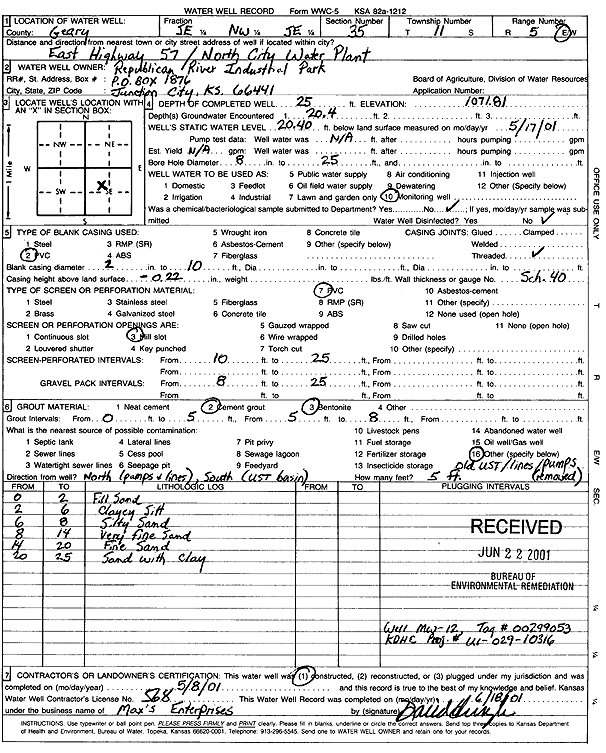
Specific Water Well Detail |
|
|
| Location Info | |||
| Owner: Republican River Industrial Park | Status: Constructed | ||
| Location: T11S, R5E, Sec. 35, SE NW SE | County: Geary | ||
| Directions: from City Water Plant: E of Hwy 57, N (Tag 00299053) | |||
| Latitude: 39.0489753 | Longitude: -96.8381327 | Datum NAD 27 | |
| Latitude: 39.0489733 | Longitude: -96.8384197 | Datum NAD 83 | |
| Longitude and latitude calculated by Survey from township-range-section-quarter calls. Only good to within the quarter call accuracy. | |||
| View well on interactive map | |||
| General Info | ||
| Well Depth: 25 ft. | Elevation: 1071.81 ft. | |
| Static Water Level: 20.4 ft. | Est. Yield: gpm. | |
| Comp. Date: 08-May-2001 | Well Use: Monitoring well/observation/piezometer | |
| DWR Applic. #: | Other ID: MW 12 | |
| Driller Info | ||
| Driller: Max's Enterprise | License #: 568 | |
| Scanned Form | View scan |
|
Chemical Sample Submitted?:
Water Well disinfected?: | ||
| Casing Info | ||
| Casing Type:
Casing Joints: |
Diam: in. to ft | |
| Casing height above land surface: in
Casing Weight: lbs/ft Wall thickness or gauge no.: | ||
| Screen and Perforation Info | ||
| Screen Type: | Screen Openings: | |
| Screen-perforated intervals | From: ft to ft | |
| Gravel pack intervals | From: ft to ft | |
| Grout Info | ||
| Grout used: | From: to ft | |
| Source of Possible Contamination | ||
| Source: | ||
| Direction from well: | Distance: ft | |
| Lithologic Log
(Log data entered by KGS.) | ||
| From: 0 ft. to 2 ft. | fill sand | |
| From: 2 ft. to 6 ft. | clayey silt | |
| From: 6 ft. to 8 ft. | silty sand | |
| From: 8 ft. to 14 ft. | very fine sand | |
| From: 14 ft. to 20 ft. | fine sand | |
| From: 20 ft. to 25 ft. | sand with clay | |