|
|
|
Specific Water Well Detail |
|
|
| Location Info | |||
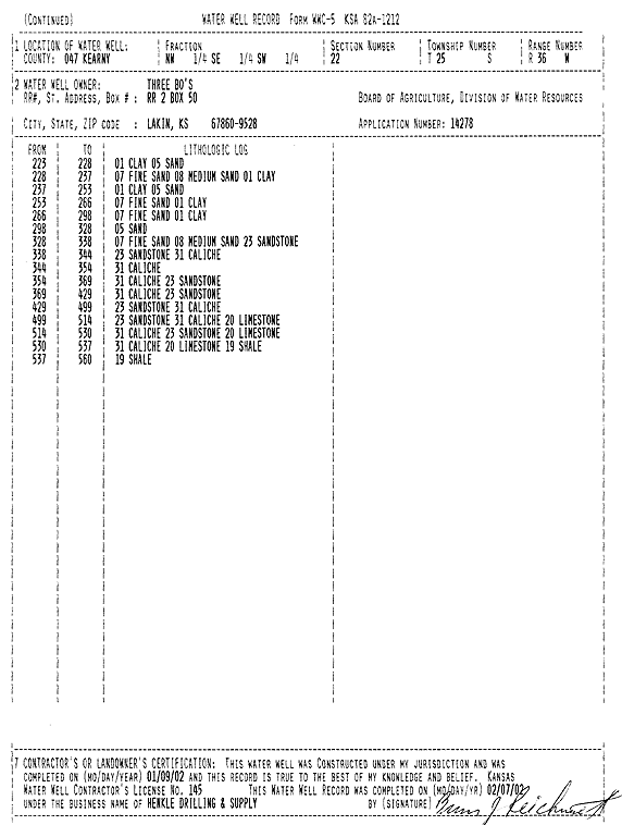
| Owner: Three Bo's | Status: Constructed | ||
| Location: T25S, R36W, Sec. 22, NW SE SW | County: Kearny | ||
| Directions: from Lakin: 4.75 mi S, 2.75 mi W | |||
| Latitude: 37.8600928 | Longitude: -101.2616341 | Datum NAD 27 | |
| Latitude: 37.8601117 | Longitude: -101.2620827 | Datum NAD 83 | |
| Longitude and latitude calculated by Survey from township-range-section-quarter calls. Only good to within the quarter call accuracy. | |||
| View well on interactive map | |||
| General Info | ||
| Well Depth: 519 ft. | Elevation: ft. | |
| Static Water Level: 119 ft. | Est. Yield: gpm. | |
| Comp. Date: 09-Jan-2002 | Well Use: Irrigation | |
| DWR Applic. #: 14278 | Other ID: | |
| Links | |
| No Wizard information available. | |
| View info from WIMAS Water Right Data base... | |
| Driller Info | ||
| Driller: Richard Henkle Drilling & Supply Co. Inc. | License #: 145 | |
| Scanned Form | View scan |
|
Chemical Sample Submitted?:
Water Well disinfected?: | ||
| Casing Info | ||
| Casing Type:
Casing Joints: |
Diam: in. to ft | |
| Casing height above land surface: in
Casing Weight: lbs/ft Wall thickness or gauge no.: | ||
| Screen and Perforation Info | ||
| Screen Type: | Screen Openings: | |
| Screen-perforated intervals | From: ft to ft | |
| Gravel pack intervals | From: ft to ft | |
| Grout Info | ||
| Grout used: | From: to ft | |
| Source of Possible Contamination | ||
| Source: | ||
| Direction from well: | Distance: ft | |
| Lithologic Log
(Log data entered by KGS.) | ||
| From: 0 ft. to 2 ft. | silt and sand | |
| From: 2 ft. to 16 ft. | fine sand | |
| From: 16 ft. to 75 ft. | sand and gravel | |
| From: 75 ft. to 92 ft. | clay and limestone | |
| From: 92 ft. to 123 ft. | clay | |
| From: 123 ft. to 143 ft. | fine sand and clay | |
| From: 143 ft. to 166 ft. | fine and medium sand and sandy clay | |
| From: 166 ft. to 191 ft. | sand and clay | |
| From: 191 ft. to 215 ft. | sand and fine gravel | |
| From: 215 ft. to 223 ft. | sand, fine gravel, and clay | |
| From: 223 ft. to 228 ft. | clay and sand | |
| From: 228 ft. to 237 ft. | fine and medium sand and clay | |
| From: 237 ft. to 253 ft. | clay and sand | |
| From: 253 ft. to 266 ft. | fine sand and clay | |
| From: 266 ft. to 298 ft. | fine sand and clay | |
| From: 298 ft. to 328 ft. | sand | |
| From: 328 ft. to 338 ft. | fine and medium sand and sandstone | |
| From: 338 ft. to 344 ft. | sandstone and caliche | |
| From: 344 ft. to 354 ft. | caliche | |
| From: 354 ft. to 369 ft. | caliche and sandstone | |
| From: 369 ft. to 429 ft. | caliche and sandstone | |
| From: 429 ft. to 499 ft. | sandstone and caliche | |
| From: 499 ft. to 514 ft. | sandstone, caliche, and limestone | |
| From: 514 ft. to 530 ft. | caliche, sandstone, and limestone | |
| From: 530 ft. to 537 ft. | caliche, limestone, and shale | |
| From: 537 ft. to 560 ft. | shale | |