|
|
|
Specific Water Well Detail |
|
|
| Location Info | |||
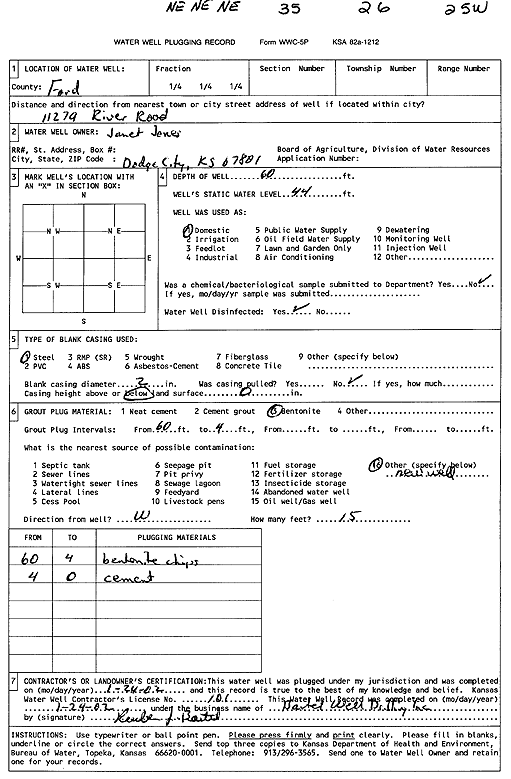
| Owner: Jones, Janet | Status: Plugged | ||
| Location: T26S, R25W, Sec. 35, NE NE NE | County: Ford | ||
| Directions: 11279 River Rd, Dodge City | |||
| Latitude: 37.7498531 | Longitude: -100.0153468 | Datum NAD 27 | |
| Latitude: 37.7498735 | Longitude: -100.0157589 | Datum NAD 83 | |
| Longitude and latitude calculated by Survey from township-range-section-quarter calls. Only good to within the quarter call accuracy. | |||
| View well on interactive map | |||
| General Info | ||
| Well Depth: 60 ft. | Elevation: ft. | |
| Static Water Level: 44 ft. | Est. Yield: gpm. | |
| Comp. Date: 24-Jan-2002 | Well Use: Domestic | |
| DWR Applic. #: | Other ID: | |
| Driller Info | ||
| Driller: Reuben Bartel Well Drilling, Inc. | License #: 101 | |
| Scanned Form | View scan |
| Casing Info | ||
|
Casing Type:
Diam: in. Casing height above land surface: in | ||
| Grout Info | ||
| Grout used: | From: to ft | |
| Source of Possible Contamination | ||
| Source: | ||
| Direction from well: | Distance: ft | |