|
|
|
Specific Water Well Detail |
|
|
| Location Info | |||
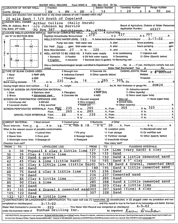
| Owner: Collins, Arthur | Status: Constructed | ||
| Location: T29S, R30W, Sec. 14, SW NW SW | County: Gray | ||
| Directions: from Copeland: 2.5 mi E, 1.25 mi S | |||
| Latitude: 37.5230359 | Longitude: -100.5779255 | Datum NAD 27 | |
| Latitude: 37.5230598 | Longitude: -100.5783573 | Datum NAD 83 | |
| Longitude and latitude calculated by Survey from township-range-section-quarter calls. Only good to within the quarter call accuracy. | |||
| View well on interactive map | |||
| General Info | ||
| Well Depth: 325 ft. | Elevation: ft. | |
| Static Water Level: 193 ft. | Est. Yield: 700 gpm. | |
| Comp. Date: 17-Mar-2002 | Well Use: Irrigation | |
| DWR Applic. #: 40327 | Other ID: | |
| Links | |
| No Wizard information available. | |
| View info from WIMAS Water Right Data base... | |
| Driller Info | ||
| Driller: Donald R. Dunham Drilling, Inc. | License #: 223 | |
| Scanned Form | View scan |
|
Chemical Sample Submitted?:
Water Well disinfected?: | ||
| Casing Info | ||
| Casing Type:
Casing Joints: |
Diam: in. to ft | |
| Casing height above land surface: in
Casing Weight: lbs/ft Wall thickness or gauge no.: | ||
| Screen and Perforation Info | ||
| Screen Type: | Screen Openings: | |
| Screen-perforated intervals | From: ft to ft | |
| Gravel pack intervals | From: ft to ft | |
| Grout Info | ||
| Grout used: | From: to ft | |
| Source of Possible Contamination | ||
| Source: | ||
| Direction from well: | Distance: ft | |
| Lithologic Log
(Log data entered by KGS.) | ||
| From: 0 ft. to 30 ft. | Topsoil and clay and little lime | |
| From: 30 ft. to 39 ft. | Clay and little lime | |
| From: 39 ft. to 42 ft. | Sand and gravel | |
| From: 42 ft. to 45 ft. | Clay and lime (little hard) | |
| From: 45 ft. to 55 ft. | Clay and little lime (little Hard) | |
| From: 55 ft. to 60 ft. | Sand | |
| From: 60 ft. to 75 ft. | Sand and clay and little lime | |
| From: 75 ft. to 79 ft. | Sand | |
| From: 79 ft. to 85 ft. | Clay and little lime | |
| From: 85 ft. to 90 ft. | Clay and lime | |
| From: 90 ft. to 93 ft. | Sand | |
| From: 93 ft. to 105 ft. | Sand and Gravel and cemented sand | |
| From: 105 ft. to 122 ft. | Sand | |
| From: 122 ft. to 127 ft. | Clay and little lime | |
| From: 127 ft. to 129 ft. | Lime (very hard) and clay | |
| From: 129 ft. to 135 ft. | Sand | |
| From: 135 ft. to 150 ft. | Sand and little cemented sand | |
| From: 150 ft. to 165 ft. | Sand and 1 foot clay | |
| From: 165 ft. to 180 ft. | Sand and Gravel, cemented sand | |
| From: 180 ft. to 195 ft. | Sand and little cemented sand | |
| From: 195 ft. to 236 ft. | Sand | |
| From: 236 ft. to 237 ft. | Cemented sand | |
| From: 237 ft. to 285 ft. | Sand | |
| From: 285 ft. to 288 ft. | Sand and little cemented sand | |
| From: 288 ft. to 303 ft. | Clay and little lime | |
| From: 303 ft. to 307 ft. | Sand (fine) and clay | |
| From: 307 ft. to 328 ft. | Sand | |