|
|
|
Specific Water Well Detail |
|
|
| Location Info | |||
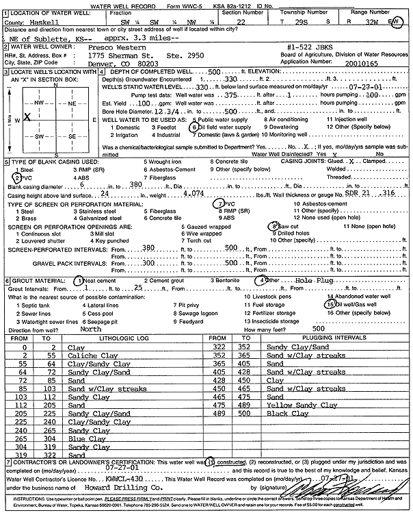
| Owner: Presco Western | Status: Constructed | ||
| Location: T29S, R32W, Sec. 22, SW SW NW | County: Haskell | ||
| Directions: from Sublette: 3.3 mi NE | |||
| Latitude: 37.5120944 | Longitude: -100.8148841 | Datum NAD 27 | |
| Latitude: 37.5121191 | Longitude: -100.8153236 | Datum NAD 83 | |
| Longitude and latitude calculated by Survey from township-range-section-quarter calls. Only good to within the quarter call accuracy. | |||
| View well on interactive map | |||
| General Info | ||
| Well Depth: 500 ft. | Elevation: ft. | |
| Static Water Level: 330 ft. | Est. Yield: gpm. | |
| Comp. Date: 27-Jul-2001 | Well Use: Oil Field Water Supply | |
| DWR Applic. #: 20010165 | Other ID: JBKS 1-522 | |
| Links | |
| No Wizard information available. | |
| View info from WIMAS Water Right Data base... | |
| Driller Info | ||
| Driller: Howard Drilling Company AG, LLC | License #: 430 | |
| Scanned Form | View scan |
|
Chemical Sample Submitted?:
Water Well disinfected?: | ||
| Casing Info | ||
| Casing Type:
Casing Joints: |
Diam: in. to ft | |
| Casing height above land surface: in
Casing Weight: lbs/ft Wall thickness or gauge no.: | ||
| Screen and Perforation Info | ||
| Screen Type: | Screen Openings: | |
| Screen-perforated intervals | From: ft to ft | |
| Gravel pack intervals | From: ft to ft | |
| Grout Info | ||
| Grout used: | From: to ft | |
| Source of Possible Contamination | ||
| Source: | ||
| Direction from well: | Distance: ft | |
| Lithologic Log
(Log data entered by KGS.) | ||
| From: 0 ft. to 2 ft. | clay | |
| From: 2 ft. to 55 ft. | caliche clay | |
| From: 55 ft. to 64 ft. | clay/sandy clay | |
| From: 64 ft. to 72 ft. | sandy clay/sand | |
| From: 72 ft. to 85 ft. | sand | |
| From: 85 ft. to 103 ft. | sand with clay streaks | |
| From: 103 ft. to 112 ft. | sandy clay | |
| From: 112 ft. to 205 ft. | sand | |
| From: 205 ft. to 225 ft. | sandy clay/sand | |
| From: 225 ft. to 240 ft. | clay/sandy clay | |
| From: 240 ft. to 265 ft. | sandy clay | |
| From: 265 ft. to 304 ft. | blue clay | |
| From: 304 ft. to 319 ft. | sandy clay | |
| From: 319 ft. to 322 ft. | sand | |
| From: 322 ft. to 352 ft. | sandy clay/sand | |
| From: 352 ft. to 365 ft. | sand with clay streaks | |
| From: 365 ft. to 405 ft. | sand | |
| From: 405 ft. to 428 ft. | sand with clay streaks | |
| From: 428 ft. to 450 ft. | clay | |
| From: 450 ft. to 465 ft. | sand with clay streaks | |
| From: 465 ft. to 475 ft. | sand | |
| From: 475 ft. to 489 ft. | yellow sandy clay | |
| From: 489 ft. to 500 ft. | black clay | |