|
|
|
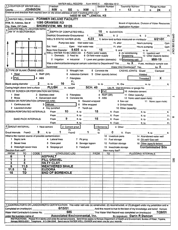
Specific Water Well Detail |
|
|
| Location Info | |||
| Owner: Former Deluxe Facility | Status: Constructed | ||
| Location: T13S, R24E, Sec. 9, NW SE NW | County: Johnson | ||
| Directions: 14600 W 106th, Lenexa | |||
| Latitude: 38.9374014 | Longitude: -94.7547945 | Datum NAD 27 | |
| Latitude: 38.9374079 | Longitude: -94.7550327 | Datum NAD 83 | |
| Longitude and latitude calculated by Survey from township-range-section-quarter calls. Only good to within the quarter call accuracy. | |||
| View well on interactive map | |||
| General Info | ||
| Well Depth: 15 ft. | Elevation: ft. | |
| Static Water Level: 4.03 ft. | Est. Yield: gpm. | |
| Comp. Date: 13-Jun-2001 | Well Use: Monitoring well/observation/piezometer | |
| DWR Applic. #: | Other ID: MW 19 | |
| Driller Info | ||
| Driller: Associated Environmental, Inc. | License #: 585 | |
| Scanned Form | View scan |
|
Chemical Sample Submitted?:
Water Well disinfected?: | ||
| Casing Info | ||
| Casing Type:
Casing Joints: |
Diam: in. to ft | |
| Casing height above land surface: in
Casing Weight: lbs/ft Wall thickness or gauge no.: | ||
| Screen and Perforation Info | ||
| Screen Type: | Screen Openings: | |
| Screen-perforated intervals | From: ft to ft | |
| Gravel pack intervals | From: ft to ft | |
| Grout Info | ||
| Grout used: | From: to ft | |
| Source of Possible Contamination | ||
| Source: | ||
| Direction from well: | Distance: ft | |
| Lithologic Log
(Log data entered by KGS.) | ||
| From: 0 ft. to 1 ft. | asphalt | |
| From: 2 ft. to 3 ft. | fill gravel | |
| From: 3 ft. to 5 ft. | silty clay | |
| From: 5 ft. to 11.5 ft. | weathered shale | |
| From: 11.5 ft. to 15 ft. | Eudora Shale | |