|
|
|
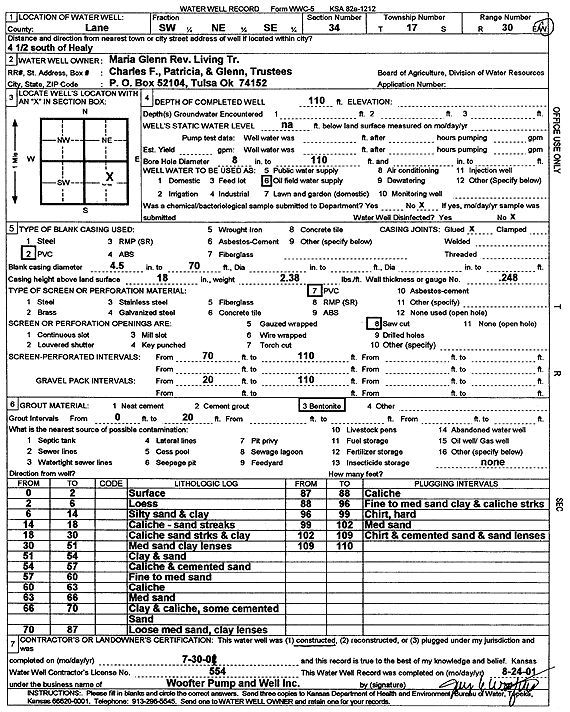
Specific Water Well Detail |
|
|
| Location Info | |||
| Owner: Maria Glenn Rev. Living Trust | Status: Constructed | ||
| Location: T17S, R30W, Sec. 34, SW NE SE | County: Lane | ||
| Directions: from Healy: 4.5 mi S | |||
| Latitude: 38.5303462 | Longitude: -100.6163114 | Datum NAD 27 | |
| Latitude: 38.5303631 | Longitude: -100.6167327 | Datum NAD 83 | |
| Longitude and latitude calculated by Survey from township-range-section-quarter calls. Only good to within the quarter call accuracy. | |||
| View well on interactive map | |||
| General Info | ||
| Well Depth: 110 ft. | Elevation: ft. | |
| Static Water Level: ft. | Est. Yield: gpm. | |
| Comp. Date: 30-Jul-2001 | Well Use: Oil Field Water Supply | |
| DWR Applic. #: | Other ID: | |
| Links | |
| No Wizard information available. | |
| View info from WIMAS Water Right Data base... | |
| Driller Info | ||
| Driller: Jay C. Woofter Pump & Well, Inc. | License #: 554 | |
| Scanned Form | View scan |
|
Chemical Sample Submitted?:
Water Well disinfected?: | ||
| Casing Info | ||
| Casing Type:
Casing Joints: |
Diam: in. to ft | |
| Casing height above land surface: in
Casing Weight: lbs/ft Wall thickness or gauge no.: | ||
| Screen and Perforation Info | ||
| Screen Type: | Screen Openings: | |
| Screen-perforated intervals | From: ft to ft | |
| Gravel pack intervals | From: ft to ft | |
| Grout Info | ||
| Grout used: | From: to ft | |
| Source of Possible Contamination | ||
| Source: | ||
| Direction from well: | Distance: ft | |
| Lithologic Log
(Log data entered by KGS.) | ||
| From: 0 ft. to 2 ft. | Surface | |
| From: 2 ft. to 6 ft. | Loess | |
| From: 6 ft. to 14 ft. | Silty sand and clay | |
| From: 14 ft. to 18 ft. | Caliche with sand streaks | |
| From: 18 ft. to 30 ft. | Caliche, sand streaks, and clay | |
| From: 30 ft. to 51 ft. | Medium sand with clay lenses | |
| From: 51 ft. to 54 ft. | Clay and sand | |
| From: 54 ft. to 57 ft. | Caliche and cemented sand | |
| From: 57 ft. to 60 ft. | Fine to medium sand | |
| From: 60 ft. to 63 ft. | Caliche | |
| From: 63 ft. to 66 ft. | Medium sand | |
| From: 66 ft. to 70 ft. | Clay and caliche, some cemented sand | |
| From: 70 ft. to 87 ft. | Loose medium sand, clay lenses | |
| From: 87 ft. to 88 ft. | Caliche | |
| From: 88 ft. to 96 ft. | Fine to medium sand, clay and caliche streaks | |
| From: 96 ft. to 99 ft. | Chert, hard | |
| From: 99 ft. to 102 ft. | Medium sand | |
| From: 102 ft. to 109 ft. | Chert and cemented sand and sand lenses | |