|
|
|
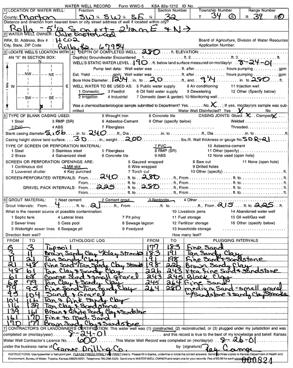
Specific Water Well Detail |
|
|
| Location Info | |||
| Owner: Easterwood, Dale | Status: Constructed | ||
| Location: T34S, R39W, Sec. 32, SW SW SE | County: Morton | ||
| Directions: from Rolla - 5.5 mi S on pavement, 2.5 mi E, N into site | |||
| Latitude: 37.0404462 | Longitude: -101.5810931 | Datum NAD 27 | |
| Latitude: 37.0404726 | Longitude: -101.5815314 | Datum NAD 83 | |
| Longitude and latitude calculated by Survey from township-range-section-quarter calls. Only good to within the quarter call accuracy. | |||
| View well on interactive map | |||
| General Info | ||
| Well Depth: 280 ft. | Elevation: ft. | |
| Static Water Level: 190 ft. | Est. Yield: gpm. | |
| Comp. Date: 24-Aug-2001 | Well Use: Domestic | |
| DWR Applic. #: | Other ID: | |
| Driller Info | ||
| Driller: Ray Cramer Drilling Co. | License #: 600 | |
| Scanned Form | View scan |
|
Chemical Sample Submitted?:
Water Well disinfected?: | ||
| Casing Info | ||
| Casing Type:
Casing Joints: |
Diam: in. to ft | |
| Casing height above land surface: in
Casing Weight: lbs/ft Wall thickness or gauge no.: | ||
| Screen and Perforation Info | ||
| Screen Type: | Screen Openings: | |
| Screen-perforated intervals | From: ft to ft | |
| Gravel pack intervals | From: ft to ft | |
| Grout Info | ||
| Grout used: | From: to ft | |
| Source of Possible Contamination | ||
| Source: | ||
| Direction from well: | Distance: ft | |
| Lithologic Log
(Log data entered by KGS.) | ||
| From: 0 ft. to 3 ft. | topsoil | |
| From: 3 ft. to 11 ft. | brown sandy clay with clay streaks | |
| From: 11 ft. to 21 ft. | tan sandy clay | |
| From: 21 ft. to 48 ft. | fine sand with tan sandy clay streaks | |
| From: 48 ft. to 61 ft. | tan clay and sandy clay | |
| From: 61 ft. to 68 ft. | coarse sand and small gravel | |
| From: 68 ft. to 79 ft. | tan clay and sandy clay | |
| From: 79 ft. to 95 ft. | fine sand with tan sandy clay | |
| From: 95 ft. to 104 ft. | sand and gravel | |
| From: 104 ft. to 116 ft. | tan and pink sandy clay | |
| From: 116 ft. to 139 ft. | tan clay and sandstone | |
| From: 139 ft. to 161 ft. | brown and white sandy clay and sandstone | |
| From: 161 ft. to 170 ft. | fine to medium sand | |
| From: 170 ft. to 177 ft. | brown sandy clay and sandstone | |
| From: 177 ft. to 183 ft. | fine sand | |
| From: 183 ft. to 191 ft. | tan sandy clay | |
| From: 191 ft. to 198 ft. | fine sand and sandstone | |
| From: 198 ft. to 226 ft. | brown sandy clay | |
| From: 226 ft. to 243 ft. | extra fine sand and sandstone | |
| From: 243 ft. to 245 ft. | black clay | |
| From: 245 ft. to 264 ft. | fine sand | |
| From: 264 ft. to 280 ft. | medium sand; small gravel with sandstone and sandy clay streaks | |