|
|
|
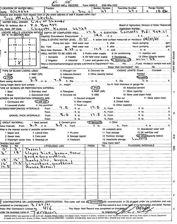
Specific Water Well Detail |
|
|
| Location Info | |||
| Owner: City of Chanute | Status: Constructed | ||
| Location: T27S, R18E, Sec. 27, SE SW | County: Neosho | ||
| Directions: | |||
| Latitude: 37.6620673 | Longitude: -95.4271058 | Datum NAD 27 | |
| Latitude: 37.6621149 | Longitude: -95.4273646 | Datum NAD 83 | |
| Longitude and latitude calculated by Survey from township-range-section-quarter calls. Only good to within the quarter call accuracy. | |||
| View well on interactive map | |||
| General Info | ||
| Well Depth: 17.5 ft. | Elevation: 904.61 ft. | |
| Static Water Level: 15.75 ft. | Est. Yield: gpm. | |
| Comp. Date: 27-Mar-2001 | Well Use: Monitoring well/observation/piezometer | |
| DWR Applic. #: | Other ID: MW 25 | |
| Driller Info | ||
| Driller: Terracon, Inc. | License #: 416 | |
| Scanned Form | View scan |
|
Chemical Sample Submitted?:
Water Well disinfected?: | ||
| Casing Info | ||
| Casing Type:
Casing Joints: |
Diam: in. to ft | |
| Casing height above land surface: in
Casing Weight: lbs/ft Wall thickness or gauge no.: | ||
| Screen and Perforation Info | ||
| Screen Type: | Screen Openings: | |
| Screen-perforated intervals | From: ft to ft | |
| Gravel pack intervals | From: ft to ft | |
| Grout Info | ||
| Grout used: | From: to ft | |
| Source of Possible Contamination | ||
| Source: | ||
| Direction from well: | Distance: ft | |
| Lithologic Log
(Log data entered by KGS.) | ||
| From: 0 ft. to 3 ft. | top soil | |
| From: 3 ft. to 15 ft. | clayey silt, brown, trace sand, gray mottling | |
| From: 15 ft. to 16 ft. | sandy clay, brown | |
| From: 16 ft. to 17.5 ft. | weathered limestone | |