|
|
|
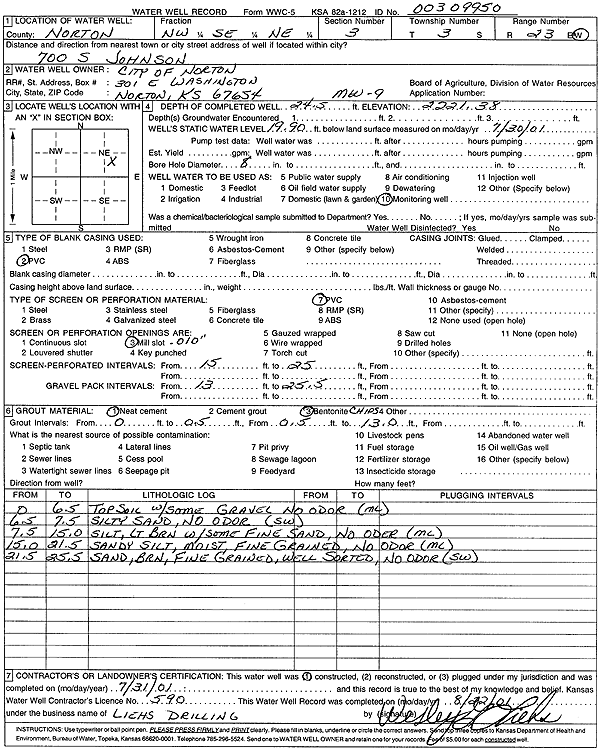
Specific Water Well Detail |
|
|
| Location Info | |||
| Owner: City of Norton | Status: Constructed | ||
| Location: T3S, R23W, Sec. 3, NW SE NE | County: Norton | ||
| Directions: 700 S Johnson, Norton | |||
| Latitude: 39.8211543 | Longitude: -99.8922349 | Datum NAD 27 | |
| Latitude: 39.821162 | Longitude: -99.892636 | Datum NAD 83 | |
| Longitude and latitude from GPS measurements. | |||
| GPS Latitude: 39.821162 | GPS Longitude: -99.892636 | Datum WGS84 | |
| View well on interactive map | |||
| General Info | ||
| Well Depth: 24.5 ft. | Elevation: 2221.38 ft. | |
| Static Water Level: 19.9 ft. | Est. Yield: gpm. | |
| Comp. Date: 31-Jul-2001 | Well Use: Monitoring well/observation/piezometer | |
| DWR Applic. #: | Other ID: MW 9 | |
| Driller Info | ||
| Driller: Wesley G. Liehs Drilling, Inc. | License #: 590 | |
| Scanned Form | View scan |
|
Chemical Sample Submitted?:
Water Well disinfected?: | ||
| Casing Info | ||
| Casing Type:
Casing Joints: |
Diam: in. to ft | |
| Casing height above land surface: in
Casing Weight: lbs/ft Wall thickness or gauge no.: | ||
| Screen and Perforation Info | ||
| Screen Type: | Screen Openings: | |
| Screen-perforated intervals | From: ft to ft | |
| Gravel pack intervals | From: ft to ft | |
| Grout Info | ||
| Grout used: | From: to ft | |
| Source of Possible Contamination | ||
| Source: | ||
| Direction from well: | Distance: ft | |
| Lithologic Log
(Log data entered by KGS.) | ||
| From: 0 ft. to 6.5 ft. | top soil, with some gravel, no odor | |
| From: 6.5 ft. to 7.5 ft. | silty sand, no odor | |
| From: 7.5 ft. to 15 ft. | silt, light brown, with some fine sand, no odor | |
| From: 15 ft. to 21.5 ft. | sandy silt, moist, fine grained, no odor | |
| From: 21.5 ft. to 25.5 ft. | sand, brown, fine grained, well sorted, no odor | |