|
|
|
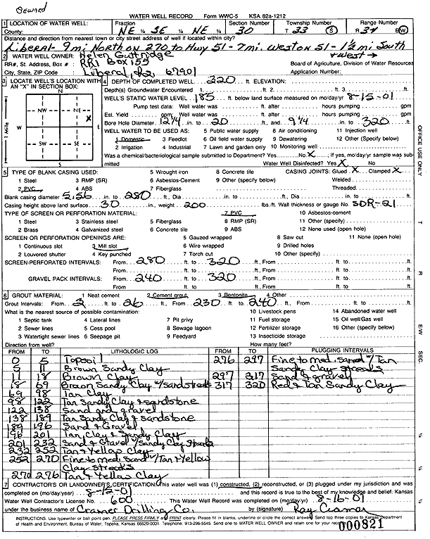
Specific Water Well Detail |
|
|
| Location Info | |||
| Owner: Guttridge, Helen | Status: Constructed | ||
| Location: T33S, R34W, Sec. 30, NE SE NE | County: Seward | ||
| Directions: from Liberal: 9 mi N on 270, 7 mi W on Hwy 51, 1.5 mi S, 1.5 mi W | |||
| Latitude: 37.150836 | Longitude: -101.0500237 | Datum NAD 27 | |
| Latitude: 37.150861 | Longitude: -101.0504666 | Datum NAD 83 | |
| Longitude and latitude calculated by Survey from township-range-section-quarter calls. Only good to within the quarter call accuracy. | |||
| View well on interactive map | |||
| General Info | ||
| Well Depth: 320 ft. | Elevation: ft. | |
| Static Water Level: 185 ft. | Est. Yield: gpm. | |
| Comp. Date: 15-Aug-2001 | Well Use: Domestic | |
| DWR Applic. #: | Other ID: | |
| Driller Info | ||
| Driller: Ray Cramer Drilling Co. | License #: 600 | |
| Scanned Form | View scan |
|
Chemical Sample Submitted?:
Water Well disinfected?: | ||
| Casing Info | ||
| Casing Type:
Casing Joints: |
Diam: in. to ft | |
| Casing height above land surface: in
Casing Weight: lbs/ft Wall thickness or gauge no.: | ||
| Screen and Perforation Info | ||
| Screen Type: | Screen Openings: | |
| Screen-perforated intervals | From: ft to ft | |
| Gravel pack intervals | From: ft to ft | |
| Grout Info | ||
| Grout used: | From: to ft | |
| Source of Possible Contamination | ||
| Source: | ||
| Direction from well: | Distance: ft | |
| Lithologic Log
(Log data entered by KGS.) | ||
| From: 0 ft. to 5 ft. | topsoil | |
| From: 5 ft. to 11 ft. | brown sandy clay | |
| From: 11 ft. to 18 ft. | brown clay | |
| From: 18 ft. to 69 ft. | brown sandy clay with sand streaks | |
| From: 69 ft. to 98 ft. | tan clay | |
| From: 98 ft. to 122 ft. | tan sandy clay and sandstone | |
| From: 122 ft. to 138 ft. | sand and gravel | |
| From: 138 ft. to 189 ft. | tan sandy clay and sandstone | |
| From: 189 ft. to 196 ft. | sand and gravel | |
| From: 196 ft. to 201 ft. | tan, clay and sandy clay | |
| From: 201 ft. to 232 ft. | sand and gravel with sandy clay streaks | |
| From: 232 ft. to 252 ft. | tan and yellow clay | |
| From: 252 ft. to 270 ft. | fine to medium sand with tan and yellow clay streaks | |
| From: 270 ft. to 276 ft. | tan and yellow clay | |
| From: 276 ft. to 297 ft. | fine to medium sand with tan sandy clay streaks | |
| From: 297 ft. to 317 ft. | sand and gravel | |
| From: 317 ft. to 320 ft. | red and tan sandy clay | |